Banyuasin Regency
Banyuasin Regency is a regency of South Sumatra Province, Indonesia. It takes its name from the main river which stream that area, Banyuasin River. Pangkalan Balai is the regency seat. The regency borders Musi Banyuasin Regency, Jambi province and Bangka Strait to the north, Bangka Strait to the east, Ogan Komering Ilir Regency, Muara Enim Regency, and Palembang to the south, and Musi Banyuasin Regency to the west. [2] It has an area of 11,832.99 km² and had a population of 749,107 at the 2010 Census[3] and 836,914 at the 2020 Census.[4] Much of the regency is coastal lowland.[5]
Banyuasin Regency
Kabupaten Banyuasin | |
|---|---|
 Coat of arms | |
| Nickname(s): OKI | |
| Motto(s): Sedulang Setudung (Banyuasinese) (Sewadah Seatap/One in The One Roof) | |
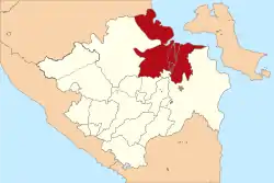 Location within South Sumatera | |
| Coordinates: 1.30°S 105.35°E | |
| Sovereign state |  Indonesia Indonesia |
| Province | South Sumatra |
| Regency seat | Pangkalan Balai |
| Onder Afdeeling (Dutch rule) | ca.1900 |
| Karesidenan | as Palembang ca.1945 |
| Kabupaten (Regency) | as Musi Banyuasin |
| Kabupaten (Regency) | since 2002 |
| Government | |
| • Type | Regency |
| • Regent / Bupati | Askolani Jasi (PDIP) |
| • Vice Regent / Wakil Bupati | Slamet Soemosentono |
| Area | |
| • Total | 11,832.99 km2 (4,568.74 sq mi) |
| Population (2020 Census)[1] | |
| • Total | 836,914 |
| • Density | 71/km2 (180/sq mi) |
| • Ethnicity | Malay Javanese |
| Time zone | UTC+7 (Western Indonesia Time) |
| Postcode | 309xx |
| Area code(s) | + 62 711 : 0711 |
| Distance from Pangkalan Balai to Palembang | 63 km |
| Website | banyuasinkab.go.id |
Administrative districts
As at 2010, the Banyuasin Regency was subdivided into fifteen districts (kecamatan), subsequently increased by six to twenty-one districts which are listed below with their areas (as at 2018, following the re-organisation of districts) and their populations at the 2010 [6]and 2020 Censuses.[7] The table also includes the location of the district administrative centres.
| District | Area in km2 | Population 2010 Census | Population 2020 Census | Administrative centre |
|---|---|---|---|---|
| Rantau Bayur | 556.91 | 38,319 | 40,150 | Tebing Abang |
| Betung | 354.41 | 55,922 | 55,020 | Betung |
| Suak Tapeh | 312.70 | (a) | 18,920 | Lubuk Lancang |
| Pulau Rimau | 454.71 | 38,454 | 21,240 | Teluk Betung |
| Tungkal Ilir | 648.14 | 23,281 | 28,140 | Sido Mulyo |
| Selat Penuguan | 433.93 | (b) | 21,620 | Wonodadi |
| Banyuasin III | 294.20 | 86,183 | 67,130 | Pangkalan Balai |
| Sembawa | 196.14 | (c) | 32,570 | Sembawa |
| Talung Kelapa | 439.43 | 123,192 | 142,460 | Sukajadi |
| Tanjung Lago | 186.69 | 35,687 | 40,330 | Tanjung Lado |
| Banyuasin I | 802.42 | 69,860 | 55,530 | Mariana |
| Air Kumbang | 328.56 | (d) | 26,130 | Cinta Manis Baru |
| Rambutan | 450.04 | 41,953 | 41,860 | Rambutan |
| Muara Padang | 917.60 | 25,198 | 30,810 | Muara Padang |
| Muara Sugihan | 696.40 | 36,971 | 37,820 | Tirta Harja |
| Makarti Jaya | 300.28 | 32,819 | 25,420 | Makarti Jaya |
| Air Saleh | 311.57 | 28,858 | 34,520 | Saleh Mukti |
| Banyuasin II | 3,494.48 | 45,072 | 27,540 | Sungsang I |
| Karang Agung Ilir | 137.92 | (e) | 11,270 | Jati Sari |
| Muara Telang | 341.57 | 52,783 | 36,980 | Telang Jaya |
| Sumber Marga Telang | 174.89 | (f) | 23,300 | Muara Telang |
| Totals | 11,832.99 | 749,107 | 818,770 (g) |
Notes:
(a) 2010 population included in figure for Betung and Banyuasin III districts, from parts of which it was created in 2011.
(b) 2010 population included in figure for Pulau Rimau district, from part of which it was created.
(c) 2010 population included in figure for Banyuasin III district, from part of which it was created in 2011.
(d) 2010 population included in figure for Banyuasin I and Rambutan districts, from parts of which it was created in 2012.
(e) 2010 population included in figure for Banyuasin II district, from part of which it was created.
(f) 2010 population included in figure for Muara Telang district, from part of which it was created in 2016.
(g) There is a considerable discrepancy between the BPS Province's figure for the Regency of 836,914 and the BPS Regency's figure of 818,770 for the districts.
References
- Badan Pusat Statistik, Jakarta, 2021.
- http://banyuasinkab.go.id/?nmodul=halaman&judul=letak-geografis-banyuasin
- Biro Pusat Statistik, Jakarta, 2011
- Badan Pusat Statistik, Jakarta, 2021.
- Potential and prospects for development Archived July 4, 2011, at the Wayback Machine, Simperdal, accessed 19 February 2011
- Biro Pusat Statistik, Jakarta, 2011.
- Badan Pusat Statistik, Jakarta, 2021.
Regencies and cities of South Sumatra | ||
|---|---|---|
Capital: Palembang | ||
| Regencies |  | |
| Cities | ||