Penukal Abab Lematang Ilir Regency
Penukal Abab Lematang Ilir Regency (often abbreviated to PALI) is a regency of South Sumatra Province, Indonesia. It takes its name from the three main rivers which flow through that area - the Penukal River, Abab River and Lematang River - while the name Ilir means "downstream" (it denote the downstream part of the Lematang River). Talang Ubi is the administrative centre of this regency. The regency borders Musi Banyuasin Regency to the north, Banyuasin Regency, and Muara Enim Regency to the east and the south, and by Musi Rawas Regency, and Muara Enim Regency to the west.[2]
Penukal Abab Lematang Ilir Regency
Kabupaten Penukal Abab Lematang Ilir PALI Regency | |
|---|---|
 Coat of arms | |
| Nickname(s): PALI | |
| Motto(s): Serepat Serasan | |
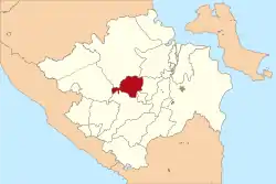 Location within South Sumatra | |
| Coordinates: 3.2134°S 104.0872°E | |
| Country |  Indonesia Indonesia |
| Region | Sumatra |
| Province | South Sumatra |
| Historic residency | Palembang Residency |
| Established | 11 January 2013 |
| Founded by | Government of Indonesia |
| Regency seat | Talang Ubi |
| Government | |
| • Type | Regency Government |
| • Regent | Heri Amalindo |
| • Vice Regent | Ferdian Andreas Lacony |
| Area | |
| • Total | 1,840.00 km2 (710.43 sq mi) |
| Population (2020 Census)[1] | |
| • Total | 194,900 |
| • Density | 110/km2 (270/sq mi) |
| • Ethnicity | Malay Javanese |
| Time zone | UTC+7 (Indonesia Western Standard Time) |
| Postcode | 312xx |
| Area code | (+62) 713 |
| Website | palikab.go.id |

The regency was established on 14 December 2012, comprising five districts which were formerly part of Muara Enim Regency.[3] These five districts had a combined area of 1,840.00 km2 and a population of 165,474 at the 2010 Census and 194,900 at the 2020 Census.[4]
Administrative districts
Penukal Abab Lematang Ilir Regency is composed of the following five districts (kecamatan), listed below with their areas and populations at the 2010 Census[5] and 2020 Census,[6] together with the locations of the district administrative centres.
| Name | Area (in km2) | Population Census 2010 | Population Census 2020 | Administrative centre |
|---|---|---|---|---|
| Talang Ubi | 648.40 | 67,258 | 83,669 | Handayani Mulia |
| Tanah Abang | 156.60 | 27,237 | 30,576 | Tanah Abang Selatan |
| Abab | 416.00 | 23,207 | 27,058 | Prabumenang |
| Penukal | 272.00 | 26,978 | 30,178 | Babat |
| Penukal Utara | 347.00 | 20,794 | 23,419 | Betung |
| Totals | 1,840.00 | 154,474 | 194,900 | Talang Ubi |
References
- Badan Pusat Statistik, Jakarta, 2021.
- http://palikab.go.id/html/profil.php?id=profil&kode=12&profil=Sejarah%20Singkat
- DPR Sahkan 7 Kabupaten Baru. www.kompas.com. Sabtu, 15 December 2012. Accessed 30 December 2012
- Badan Pusat Statistik, Jakarta, 2021.
- Biro Pusat Statistik, Jakarta, 2011.
- Badan Pusat Statistik, Jakarta, 2021.
Regencies and cities of South Sumatra | ||
|---|---|---|
Capital: Palembang | ||
| Regencies |  | |
| Cities | ||