Lahat Regency
Lahat Regency is a regency of South Sumatra (or Sumatra Selatan) province, Indonesia. It covers a total area of 4,361.83 km2 and had a population of 369,974 at the 2010 Census[2] and 430,071 at the 2020 Census.[3] The city of Pagar Alam is an enclave within the regency, but is administratively separate.
Lahat Regency | |
|---|---|
 Megalithic statue located on the way from Pulauping village to Tinggihari village (photo taken in 1933) | |
 Coat of arms | |
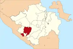 Location in South Sumatra | |
| Country | Indonesia |
| Province | South Sumatra |
| Regency seat | Lahat |
| Area | |
| • Total | 4,361.83 km2 (1,684.11 sq mi) |
| Population (2020 Census)[1] | |
| • Total | 430,071 |
| • Density | 99/km2 (260/sq mi) |
| Time zone | UTC+7 (WIB) |
The administrative centre of Lahat regency is the town of Lahat.
Administrative districts
This Regency as at 2010 was administratively composed of twenty-one districts (kecamatan). Since 2010 three additional districts have been created - Sukamerindu (from part of Pajar Bulan District), Lahat Selatan (from Lahat District) and Mulak Sebingkai (from Mulak Ulu District). Their areas (in km2) and their populations at the 2010[4] and 2020 Censuses[5] are listed below. The table also includes the number of administrative villages (rural desa and uban kelurahan) in each district, and its post codes.
| Name | Area in km2 | Population Census 2010 | Population Census 2020 | Number of villages | Post code(s) |
|---|---|---|---|---|---|
| Tanjung Sakti Pumi (a) | 271.00 | 15,032 | 16,820 | 18 | 31581 |
| Tanjung Sakti Pumu (a) | 229.59 | 13,252 | 14,520 | 14 | 21582 |
| Kota Agung | 165.59 | 12,001 | 13,623 | 22 | 31462 |
| Mulak Ulu | 108.43 | 16,539 | 12,572 | 16 | 31453 |
| Tanjung Tebat | 82.72 | 7,734 | 8,820 | 14 | 31455 |
| Mulak Sebingkai | 63.41 | (b) | 5,706 | 10 | 31454 |
| Pulau Pinang (Pinang Island) | 111.67 | 10,994 | 9,867 | 10 | 31463 |
| Pajar Guning | 105.51 | 11,568 | 12,949 | 20 | 31460 |
| Gumay Ulu | 87.01 | 4,993 | 5,583 | 10 | 31461 |
| Jarai | 167.52 | 19,231 | 20,512 | 21 | 31591 |
| Pajar Bulan | 146.11 | 18,938 | 12,853 | 20 | 31356 |
| Muara Payang | 37.50 | 8,340 | 8,904 | 7 | 31390 |
| Sukamerindu | 55.23 | (c) | 8,046 | 10 | 31350 |
| Kikim Barat (West Kikim) | 272.00 | 14,699 | 17,898 | 19 | 31452 |
| Kikim Timur (East Kikim) | 564.45 | 26,014 | 31,994 | 32 | 31458 |
| Kikim Selatan (South Kikim) | 124.80 | 14,813 | 17,340 | 18 | 31451 |
| Kikim Tengah (Central Kikim) | 265.60 | 8,193 | 10,046 | 9 | 31459 |
| Lahat (district) | 107.60 | 102,356 | 107,506 | 30 | 31411 - 31419 |
| Gumay Talang | 249.61 | 9,804 | 12,938 | 15 | 31419 |
| Lahat Selatan (South Lahat) | 183.87 | (d) | 13,208 | 10 | 31420 - 31429 |
| Pseksu | 269.29 | 7,949 | 9,042 | 11 | 31417 - 31419 |
| Merapi Barat (West Merapi) | 232.64 | 19,783 | 25,703 | 19 | 31471 |
| Merapi Timur (East Merapi) | 260.66 | 20,413 | 25,232 | 14 | 31473 |
| Merapi Selatan (South Merapi) | 200.14 | 7,328 | 8,389 | 9 | 31472 |
| Totals | 4,361.83 | 369,974 | 430,071 | 378 |
Notes: (a) The districts of Tanjung Sakti Pumu and Tanjung Sakti Pumi form an exclave of the regency, from which they are physically separated by the city (kota) of Pagar Alam.
(b) The 2010 population of Mulak Sebingkai District is included in the figure for Mulak Ulu District from which it was cut out.
(c) The 2010 population of Sukamerindu District is included in the figure for Pajar Bulan District, from which it was cut out.
(d) The 2010 population of Lahat Selatan District is included in the figure for Lahat District, from which it was cut out.
Megalithic sites
In Lahat Regency, near Pagar Alam city, there are 1,027 artifacts which spread over 40 sites in 12 communities. The megalithic sites in Lahat Regency may be the second largest such sites in Indonesia after Sangiran (Central Java) for fossils.[6]
References
- Badan Pusat Statistik, Jakarta, 2021.
- Biro Pusat Statistik, Jakarta, 2011.
- Badan Pusat Statistik, Jakarta, 2021.
- Biro Pusat Statistik, Jakarta, 2011.
- Badan Pusat Statistik, Jakarta, 2021.
- "Pemkab Lahat Gali Ribuan Megalit". October 12, 2012. Archived from the original on January 28, 2013. Retrieved October 17, 2012.
External links
Regencies and cities of South Sumatra | ||
|---|---|---|
Capital: Palembang | ||
| Regencies |  | |
| Cities | ||
Authority control  | |
|---|---|
| General | |
| National libraries | |