Ogan Ilir Regency
Ogan Ilir Regency (abbreviation OI) is a regency of South Sumatra Province, Indonesia. It takes its name from the main river which stream that area, Ogan River. And the name Ilir means downstream. Indralaya is the regency seat. The regency borders Palembang, and Muara Enim Regency to the north, Ogan Komering Ilir Regency to the east, Ogan Komering Ilir Regency, and East Ogan Komering Ulu Regency to the south, and Muara Enim Regency to the west.[2]
Ogan Ilir Regency
Kabupaten Ogan Ilir OI Regency | |
|---|---|
 Coat of arms | |
| Nickname(s): OI | |
| Motto(s): Caram Seguguk (Kebersamaan dan Gotong Royong/Togetherness and Mutual Cooperation) | |
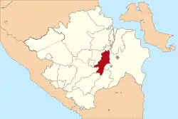 Location within South Sumatera | |
| Coordinates: 3.02°S 104.48°E | |
| Sovereign state |  Indonesia Indonesia |
| province | South Sumatra |
| Regency seat | Indralaya |
| Onder Afdeeling (Dutch rule) | as Ogan Ilir ca.1900 |
| Karesidenan | as Palembang ca.1945 |
| Kabupaten (Regency) | as Ogan Komering Ilir since 1956 |
| Kabupaten (Regency) | since 2003 |
| Government | |
| • Type | Regency |
| • Regent / Bupati | Mawardi Yahya |
| • Vice Regent / Wakil Bupati | Muhammad Daud Hasyim |
| Area | |
| • Total | 2,666.07 km2 (1,029.38 sq mi) |
| Population (2020 Census) | |
| • Total | 416,549 |
| • Density | 160/km2 (400/sq mi) |
| • Ethnicity | Malay (Ogan Pegagan Penesak) Javanese |
| [1] | |
| Time zone | UTC+7 (Western Indonesia Time) |
| Postcode | 306xx, 308xx |
| Area code(s) | + 62 711 : 0711, + 62 712 : 0712 |
| Distance from Inderalaya to Palembang | 32 km |
| Website | oganilirkab.go.id |
Ogan Ilir Regency covers an area of 2,666.07 km², and had a population of 380,904 at the 2010 Census[3] and 416,549 at the 2020 Census.[4]
Administrative districts
Based on Presidential Decree No.37/2003, Ogan Komering Ilir Regency was divided into two regencies, namely Ogan Komering Ilir Regency and Ogan Ilir Regency. Ogan Ilir Regency then included the six districts of Indralaya (as the capital), Tanjung Raja, Tanjung Batu, Muara Kuang, Pemulutan and Rantau Alai. This Regency is now administratively composed of sixteen districts (kecamatan), comprising 241 villages (14 urban kelurahan and 227 rural desa). Their areas (in km2) and their populations at the 2010 Census[5] and the 2020 Census[6] are listed below. The table also includes the number of administrative villages in each district, and its postal codes.
| Name | Area (in km2) | Population Census 2010 | Population Census 2020 | Number of villages | Post code |
|---|---|---|---|---|---|
| Muara Kuang | 300.75 | 17,430 | 19,759 | 14 | 30865 |
| Rambang Kuang | 528.82 | 19,780 | 20,838 | 13 | 30869 |
| Lubuk Keliat | 207.67 | 16,484 | 17,755 | 10 | 30868 |
| Tanjung Batu | 263.75 | 42,158 | 46,931 | 21 | 30665 |
| Payaraman | 180.57 | 21,728 | 25,909 | 13 | 30664 |
| Rantau Alai | 62.16 | 10,713 | 10,801 | 13 | 30866 |
| Kandis | 50.25 | 10,293 | 10,635 | 12 | 30867 |
| Tanjung Raya | 70.41 | 40,873 | 43,612 | 19 | 30663 |
| Rantau Panjang | 40.85 | 16,481 | 17,029 | 12 | 30661 |
| Sungai Pinang | 42.62 | 23,122 | 25,896 | 13 | 30662 |
| Pemulutan | 122.92 | 40,708 | 46,128 | 25 | 20663 |
| Pemulutan Selatan (South Pemulutan) | 61.49 | 16,426 | 16,710 | 15 | 30663 |
| Pemulutan Barat (West Pemulutan) | 60.00 | 12,428 | 13,799 | 11 | 30663 |
| Indralaya | 101.22 | 37,553 | 40,634 | 20 | 30862 (a) |
| Indralaya Utara (North Indralaya) | 472.33 | 34,421 | 38,027 | 16 | 30862 (b) |
| Indralaya Selatan (South Indralaya) | 100.26 | 20,306 | 22,086 | 14 | 30862 |
| Totals | 2,667.07 | 380,904 | 416,549 | 241 |
Notes: (a) except for four villages - Sakatiga Seberang (with post code of 30814), Tanjung Sejaro (with post code of 30815), Sakatiga (with post code of 30816) and Tanjung Seteko (with post code of 30817). (b) except for two villages - Payakabung (with post code of 30812) and Tanjung Pering (with post code of 30813).
References
- Badan Pusat Statistik, Jakarta, 2021.
- http://www.kemendagri.go.id/pages/profil-daerah/kabupaten/id/16/name/sumatera-selatan/detail/1610/ogan-ilir
- Biro Pusat Statistik, Jakarta, 2011.
- Badan Pusat Statistik, Jakarta, 2021.
- Biro Pusat Statistik, Jakarta, 2011.
- Badan Pusat Statistik, Jakarta, 2020.
Regencies and cities of South Sumatra | ||
|---|---|---|
Capital: Palembang | ||
| Regencies |  | |
| Cities | ||