Kamoenai, Hokkaido
Kamoenai (神恵内村, Kamoenai-mura) is a village located in Shiribeshi Subprefecture, Hokkaido, Japan. It is the second smallest municipality in Hokkaido by population, after Otoineppu.
Kamoenai
神恵内村 | |
|---|---|
Village | |
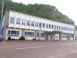 Kamoenai village office | |
 Flag  Emblem | |
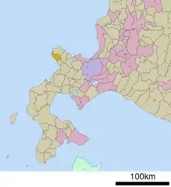 Location of Kamoenai in Hokkaido (Shiribeshi Subprefecture) | |
  Kamoenai Location in Japan | |
| Coordinates: 43°9′N 140°26′E | |
| Country | Japan |
| Region | Hokkaido |
| Prefecture | Hokkaido (Shiribeshi Subprefecture) |
| District | Furuu |
| Government | |
| • Mayor | Masayuki Takahashi |
| Area | |
| • Total | 147.71 km2 (57.03 sq mi) |
| Population (September 30, 2016) | |
| • Total | 904 |
| • Density | 6.1/km2 (16/sq mi) |
| Time zone | UTC+09:00 (JST) |
| City hall address | 81-4 Kamoenaimura, Kamoenai, Furuu-gun, Hokkaido 045-0301 |
| Website | www |
| Symbols | |
| Fish | Chum salmon |
| Tree | Abies sachalinensis |
As of September 2016, the village has an estimated population of 904. The total area is 147.71 km².
Geography
Kamoenai is located on the western of the Shakotan Peninsula.
History
Kamoenai was developed by fisheries. Kamoenai Village was merged with Akaishi Village and Sannai Village and became a Second Class Village in 1906.
Education
- Kamoenai Elementary School
- Kamoenai Junior High School
External links
 Media related to Kamoenai, Hokkaidō at Wikimedia Commons
- Official Website (in Japanese)
|  | |||||||||||
|
| ||||||||||||
| ||||||||||||
| ||||||||||||
| ||||||||||||
| ||||||||||||
| ||||||||||||
| ||||||||||||
| ||||||||||||
| ||||||||||||
| ||||||||||||
| ||||||||||||
| ||||||||||||


This article is issued from Wikipedia. The text is licensed under Creative Commons - Attribution - Sharealike. Additional terms may apply for the media files.