Suttsu, Hokkaido
Suttsu (寿都町, Suttsu-chō) is a town located in Shiribeshi Subprefecture, Hokkaido, Japan.
Suttsu
寿都町 | |
|---|---|
Town | |
 Suttsu Town hall | |
 Flag  Seal | |
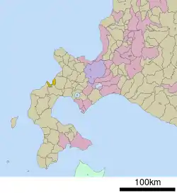 Location of Suttsu in Hokkaido (Shiribeshi Subprefecture) | |
  Suttsu Location in Japan | |
| Coordinates: 42°47′N 140°14′E | |
| Country | Japan |
| Region | Hokkaido |
| Prefecture | Hokkaido (Shiribeshi Subprefecture) |
| District | Suttsu |
| Government | |
| • Mayor | Haruo Kataoka |
| Area | |
| • Total | 95.36 km2 (36.82 sq mi) |
| Population (September 30, 2016) | |
| • Total | 3,113 |
| • Density | 33/km2 (85/sq mi) |
| Time zone | UTC+09:00 (JST) |
| City hall address | 140-1 Toshimacho, Suttsu, Suttsu-gun, Hokkaido 048-0406 |
| Website | www |
| Symbols | |
| Bird | Common gull |
| Flower | Rosa rugosa |
| Tree | Cherry blossom |
As of September 2016, the town has an estimated population of 3,113, and a density of 33 persons per km². The total area is 95.36 km².
Geography
The town of Suttsu faces the Suttsu Bay, a bay of the Sea of Japan. Shubetsu River flows in the middle of the town and divides the town into east and west.
Neighboring towns and village
Climate
Suttsu has a humid continental climate (Köppen climate classification Dfb) with warm summers and cold winters. Precipitation is significant throughout the year, but the months from March to June are somewhat drier.
| Climate data for Suttsu(elevation 33.4 m (110 ft)) | |||||||||||||
|---|---|---|---|---|---|---|---|---|---|---|---|---|---|
| Month | Jan | Feb | Mar | Apr | May | Jun | Jul | Aug | Sep | Oct | Nov | Dec | Year |
| Record high °C (°F) | 12.2 (54.0) |
11.2 (52.2) |
17.5 (63.5) |
27.7 (81.9) |
29.0 (84.2) |
31.3 (88.3) |
33.0 (91.4) |
34.0 (93.2) |
31.1 (88.0) |
25.9 (78.6) |
20.6 (69.1) |
15.1 (59.2) |
34.0 (93.2) |
| Average high °C (°F) | −0.3 (31.5) |
0.1 (32.2) |
3.5 (38.3) |
10.0 (50.0) |
15.1 (59.2) |
18.8 (65.8) |
22.3 (72.1) |
24.5 (76.1) |
21.3 (70.3) |
15.4 (59.7) |
8.3 (46.9) |
2.2 (36.0) |
11.8 (53.2) |
| Daily mean °C (°F) | −2.4 (27.7) |
−2.1 (28.2) |
1.0 (33.8) |
6.4 (43.5) |
11.0 (51.8) |
14.9 (58.8) |
18.9 (66.0) |
21.1 (70.0) |
17.8 (64.0) |
11.9 (53.4) |
5.3 (41.5) |
−0.1 (31.8) |
8.6 (47.5) |
| Average low °C (°F) | −4.9 (23.2) |
−4.6 (23.7) |
−1.8 (28.8) |
2.8 (37.0) |
7.3 (45.1) |
11.8 (53.2) |
16.4 (61.5) |
18.4 (65.1) |
14.3 (57.7) |
8.2 (46.8) |
2.1 (35.8) |
−2.7 (27.1) |
5.6 (42.1) |
| Record low °C (°F) | −15.7 (3.7) |
−15.0 (5.0) |
−11.4 (11.5) |
−7.7 (18.1) |
−1.4 (29.5) |
2.7 (36.9) |
7.1 (44.8) |
10.8 (51.4) |
4.8 (40.6) |
−3.6 (25.5) |
−9.0 (15.8) |
−15.0 (5.0) |
−15.7 (3.7) |
| Average precipitation mm (inches) | 112.1 (4.41) |
78.0 (3.07) |
58.9 (2.32) |
57.0 (2.24) |
68.4 (2.69) |
51.9 (2.04) |
88.4 (3.48) |
125.7 (4.95) |
137.7 (5.42) |
136.2 (5.36) |
142.3 (5.60) |
120.6 (4.75) |
1,177.1 (46.34) |
| Average snowfall cm (inches) | 169 (67) |
134 (53) |
79 (31) |
6 (2.4) |
0 (0) |
0 (0) |
0 (0) |
0 (0) |
0 (0) |
0 (0) |
33 (13) |
121 (48) |
546 (215) |
| Average relative humidity (%) | 70 | 69 | 67 | 69 | 74 | 82 | 85 | 84 | 78 | 71 | 68 | 69 | 74 |
| Mean monthly sunshine hours | 29.7 | 46.6 | 112.6 | 170.7 | 192.5 | 181.4 | 155.9 | 162.8 | 156.6 | 127.7 | 55.4 | 29.4 | 1,420.7 |
| Source 1: Japan Meteorological Agency (1981 - 2010)[1] | |||||||||||||
| Source 2: Japan Meteorological Agency (1884 - )[2] | |||||||||||||
History
- 1897: Suttsu Subprefecture was established.[3]
- 1900: Suttsu Town was founded and became a First Class Town.
- 1902: Isoya Village (Isoya District) was founded and became a Second Class Village.
- 1906: Utasutsu Village (Utasutsu District) was founded and became a Second Class Village.
- 1910: Suttsu Subprefecture was abolished and Shiribeshi Subprefecture was established in Kutchan.
- 1923: Masadomari Village and Tarukishi Village became Second Class Villages.
- 1933: Suttsu Town and Masadomari Village were merged to form the new town of Suttsu.
- 1955: Suttsu Town, Isoya Village, Utasutsu Village, and a part of Tarukishi Village were merged to form the new town of Suttsu.
Industry
Fisheries comprise the main economic activity of Suttsu. The town developed by the fishery of herring.[4] Because of a decrease of fishery resources, Suttsu focuses on an aquaculture business now.[5]
Education
- High school
- Hokkaido Suttsu High School[6]
- Junior high school
- Suttsu Junior High School
- Elementary school
- Suttsu Elementary School
- Oshoro Elementary School
References
- 寿都 年・月ごとの平年値 (in Japanese). Japan Meteorological Agency. Retrieved 7 March 2021.
- 寿都 観測史上1~10位の値 (in Japanese). Japan Meteorological Agency. Retrieved 7 March 2021.
- Outline of Suttsu Archived 2015-05-10 at the Wayback Machine
- Fishery of Suttsu
- Aquaculture of Suttsu
- Hokkaido Suttsu High School
External links
 Media related to Suttsu, Hokkaidō at Wikimedia Commons
- Official Website (in Japanese)
|  | |||||||||||
|
| ||||||||||||
| ||||||||||||
| ||||||||||||
| ||||||||||||
| ||||||||||||
| ||||||||||||
| ||||||||||||
| ||||||||||||
| ||||||||||||
| ||||||||||||
| ||||||||||||
| ||||||||||||

