Flemington Road, Melbourne
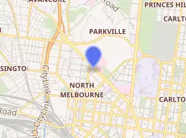
Flemington Road is a major thoroughfare in the inner suburbs of North Melbourne and Parkville in Melbourne, Victoria, Australia. It runs for 2 km in a northwest–southeast direction, from the southern end of Mount Alexander Road, Flemington, to Haymarket roundabout and the northern end of Elizabeth Street, and provides a main connection between the northern arm of the CityLink tollway and the Melbourne city centre.
Flemington Road | |
|---|---|
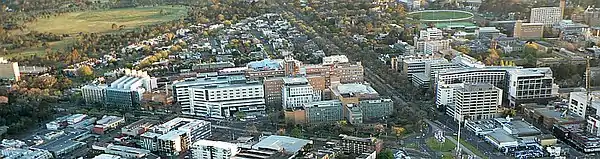 | |
Aerial view of the southeastern portion of Flemington Road (running from left to right) in 2010, prior to the construction of the Victorian Comprehensive Cancer Centre in the far southeast (bottom-right). Click to enlarge. | |
| |
| General information | |
| Type | Road |
| Length | 2 km (1.2 mi) |
| Route number(s) |  State Route 60 (2013-present) State Route 60 (2013-present)(CityLink-Harker Street) |
| Former route number |
|
| Major junctions | |
| Northwest end | Mt. Alexander Road Travancore, Melbourne |
| |
| Southeast end |  Elizabeth Street Elizabeth StreetMelbourne CBD |
| Location(s) | |
| LGA(s) | City of Melbourne |
| Major suburbs | North Melbourne, Parkville |




Facilities
The road provides access to several notable medicine and medical research institutions, as well as other facilities, particularly in the southeastern portion. It is a major healthcare precinct, containing many of inner Melbourne's hospitals. Some of these facilities are listed below, from north-westernmost to south-easternmost:
- Royal Park
- Royal Children's Hospital
- University of Melbourne Western Precinct
Transport
Flemington Road consists of four motor vehicle lanes, two in each direction, and two tram tracks, one in each direction. These tracks are within 'Zone 1' and are serviced by Yarra Trams route numbers 57, 58, and 59. The extreme north-west of Flemington Road is adjacent to Flemington Bridge railway station, which is on the Upfield railway line.
Major intersections
| LGA | Location | km | mi | Destinations | Notes |
|---|---|---|---|---|---|
| Mount Alexander Road | |||||
 CityLink (M2) – Melbourne Airport CityLink (M2) – Melbourne Airport | |||||
| Boundary Road | |||||
 Racecourse Road/Elliott Avenue Racecourse Road/Elliott Avenue | |||||
| Harker Street | |||||
| Wreckyn Street/Grattan Street | |||||
| Boundary Road | |||||
| Peel Street | |||||
| Elizabeth Street |
See also
- Flemington Road, Bowen
 Australian Roads portal
References
- Lockhart, Caris (16 June 2020). "Faculty of Veterinary and Agricultural Sciences". Faculty of Veterinary and Agricultural Sciences. Retrieved 4 July 2020.