West Gate Freeway
The West Gate Freeway[2] is a major freeway in Melbourne, the busiest urban freeway and the busiest road in Australia, carrying upwards of 200,000 vehicles per day. It links Geelong (via the Princes Freeway) and the Western suburbs to the Melbourne CBD and beyond. It is also a link between Melbourne and the west and linking industrial and residential areas west of the Yarra River with the city and port areas. The West Gate Bridge is a part of the freeway.
West Gate Freeway | |
|---|---|
.jpg.webp) | |
West Gate Bridge looking towards Melbourne CBD | |
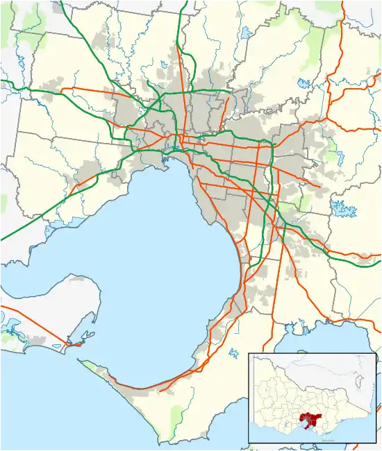  West end East end | |
| Coordinates |
|
| General information | |
| Type | Freeway |
| Length | 14 km (8.7 mi) |
| Opened | 1971-1988 |
| Route number(s) |  M1 (1997–present) M1 (1997–present) |
| Former route number |
|
| Tourist routes |  Tourist Drive 2 (1989–present) Tourist Drive 2 (1989–present)(Spotswood-Southbank) |
| Major junctions | |
| West end | Princes Freeway Laverton North, Melbourne |
| |
| East end |  CityLink CityLinkSouthbank, Melbourne |
| Location(s) | |
| LGA(s) | City of Hobsons Bay |
| Major suburbs / towns | Altona North, Spotswood, Port Melbourne |
| Highway system | |


It is a fully managed freeway with a complete 'Freeway Management System' that is dynamically linked and adaptive to the entire M1 corridor. This includes the 2008 re-design of a substantial section. Overall, the freeway has between 4-6 lanes in each direction, with a maximum of 12 lanes at one point in its width.
History
The Country Roads Board (later VicRoads) was authorised by the government in December 1961 for a study to gather engineering and economic data for the provisioning of a toll crossing of the Lower Yarra River, from Salmon Street in Port Melbourne to the Princes Highway in the vicinity of Kororoit Creek, a distance of 5.25 miles.[3] Investigations included details of bores down to 8,000 feet and soil tests (completed on 29 June 1962), selective drilling and sampling in critical areas, and traffic studies, and at the time both a tunnel under and a bridge over the river were mooted.[3] In February 1966, the Board was appointed as the design and construction authority for the Lower Yarra Crossing Project; the State government authorised the construction of a tolled bridge over the Yarra with eight lanes.[4]
Construction began on the first section of the Lower Yarra Freeway in the late 1960s and was open to traffic by 1971,[5] stretching from the intersection of the Princes Highway and Little Boundary Road in Laverton North (later enlarged and named the West Gate Interchange) eastwards to Melbourne/Williamstown Roads just west of the mouth of the Yarra, initially designated with an F-82 shield. At the time, the only way to cross the Yarra west of the CBD was via a ferry crossing, which naturally saw far heavier demands once the Lower Yarra Freeway was officially opened.
The West Gate Bridge across the Yarra had started construction not too long before the opening of the freeway and, although delayed, when finally completed in 1978[6] allowed the freeway to extend over the river and directly into the CBD's south-western corner (via Rogers and Lorimer Streets). The freeway's name was changed to the West Gate Freeway to commemorate its opening, but the freeway also attracted tolls from anyone using the bridge (between Melbourne/Williamstown Road and Rogers Street) between 16 November 1978 and 17 November 1985.[7] The toll plaza was located on the city side of the bridge where the service stations are now located.[8] National Route 1 - previously designated along Geelong Road (Princes Highway West) and through the CBD via Smithfield and Flemington Roads and King Street - was altered to use the freeway instead and rejoin Kings Way via Rogers, Lorimer and Clarendon Streets.
Due to the extra traffic the West Gate Freeway was attracting—and due to the safety concerns of having excess traffic filter through connector streets in South Melbourne—the freeway was first extended to Johnson Street (today Montague Street) in 1985,[7] and then finally to Kings Way above the Grant Street intersection using elevated carriageways; the eastbound carriageway opened in 1987.[9] Expansion of the original two lane freeway on the western side of the bridge to three lanes each way was carried out in 1993, and expansion to four lanes followed in 2000. With the subsequent completion of the Western Ring Road joining the West Gate Interchange to the freeway's west and CityLink to the freeway's east, it also funnels traffic from northern and western suburbs around Melbourne, acting as a bypass freeway.
The entire freeway has been given an M1 designation. It gains the Tourist 2 shield at the Melbourne/Williamstown Road interchange in Spotswood, and loses it at the Montague Street interchange in Port Melbourne.
The original Lower Yarra Freeway was officially designated in the 1969 Melbourne Transportation Plan as the F9 Freeway corridor.
Timeline of construction
- 1971 - Lower Yarra Freeway, initial 4 miles (6.4 km) opened from Princes Highway to Williamstown Road on 7 April 1971, originally 3 lanes in each direction, at a cost of $14 million.[5]
- 1978 - West Gate Bridge, opened 15 November 1978, by the Premier, the Hon. R J Hamer ED, MP; with freeway extension from the bridge to Rogers Street[6]
- 1985 - Tolls removed from West Gate Bridge, 17 November 1985[7]
- 1985 - Extended 1.5km from Rogers Street to Johnson Street, opened December 1985[7]
- 1987 - Extended 2.1km from Johnson Street to Kings Way, single carriageway eastbound, opened December 1987[9]
- 1988 - Extended 2.1km from Johnson Street to Kings Way, single carriageway westbound, opened October 1988; total cost for both carriageways to Kings Way/Power Street $185 million[9]
- 1990/1991 – ‘A third lane is being built in both directions on the West Gate Freeway between Princes Highway and Millers Road’.[10] This possibly conflicts with information given in the Country Roads Board's 58th Annual Report, which states that the freeway opened with three lanes in each direction in 1971, whilst omitting that the third lane only existed between Millers Road and Williamstown Road.[5]
2008 upgrade
Traffic volumes on the West Gate Freeway have grown steadily since opening, carrying up to 180,000 vehicles every day. Congestion frequently occurs at the Montague Street and Bolte Bridge interchanges due to conflicting traffic movements on and off the freeway. On 1 May 2008 the Minister for Roads and Ports Tim Pallas announced design details for the West Gate Freeway improvements, to assist in maintaining rapidly growing volume capacity and to reduce congestion[11]
They are:
- a full freeway management system, made up of Ramp Metering (Signalling), Lane Use Management Signs (overhead lane availability / variable speed zones), electronic on-road message signs, arterial road message signs, CCTV cameras and a suite of freeway traffic algorithms and software with data stations, thousands of sensors and a core server at the VicRoads TMC.
- the addition of a new elevated road structure joining the outbound Kings Way on-ramp to the Freeway
- new traffic ramps over Montague Street
- an additional dedicated exit ramp from the Bolte Bridge to the Freeway
- widening of the freeway between Todd Road and Montague Street
- redesign of the Montague Street interchange.
These works help reduce merging and weaving movements at key points on the freeway, leading to a smoother traffic flow and improved driver safety. As part of the works the Montague Street on-ramp city bound had been closed for approximately 18 months to enable the new one to be built.[12]
Early works on the West Gate Freeway, including geo-technical investigations and service proving, commenced in late 2007. In early 2008 construction works started on the freeway widening, specifically in the South Melbourne area. New traffic lanes and ramps have been completed and opened in different stages with the total project scheduled for completion in late 2010.
The Freeway Upgrade was awarded the 2011 Australian Construction Achievement Award.[13]
Route
Road conditions
The West Gate Freeway officially begins at the West Gate Interchange in Altona North, with four lanes running in each direction. The freeway flows from the Western Ring Road and the Princes Freeway with access to the Princes Highway (Geelong Road) also provided with city bound exit and Geelong bound entry ramps.
Soon after the bridge crossing, the freeway becomes elevated for its remaining length, with access ramps to Melbourne's central business district. Continuing to drive eastward on the freeway after the Power Street exit results in entering the electronically tolled CityLink, and travelling through the Burnley Tunnel.
Standard travel time on the West Gate Freeway in both directions, is 12 minutes: 5 minutes from the Western Ring Road to Williamstown Road, and 7 minutes from Williamstown Road to Kings Way).
The usual peak period travel time, is between 16–24 minutes; however, in times of extreme congestion or traffic accidents, the travel time can well exceed half an hour.
Exits and interchanges
| LGA | Location | km | mi | Exit | Destinations | Notes |
|---|---|---|---|---|---|---|
| West Gate Freeway continues east as CityLink through Domain Tunnel (westbound) and Burnley Tunnel (eastbound) | ||||||
| Melbourne | Southbank | 0 | 0.0 | W1 | Power Street – Southbank | Eastbound exit and westbound entrance only |
| 0.3 | 0.19 | W2 |  Kings Way – St Kilda, Caulfield, Dandenong Kings Way – St Kilda, Caulfield, Dandenong | Eastbound exit to and westbound entrance from the south only | ||
| 1.6 | 0.99 | W3 |   Montague Street (State Routes 30/55/Tourist Route 2 north) – Docklands Montague Street (State Route 30 south) – South Melbourne Montague Street (State Routes 30/55/Tourist Route 2 north) – Docklands Montague Street (State Route 30 south) – South Melbourne | Start of concurrency of Tourist Drive 2 | ||
| Port Melbourne | 3.1 | 1.9 | W4 |   CityLink – Tullamarine, Melbourne Airport CityLink – Tullamarine, Melbourne Airport | Trumpet interchange with local-express lanes; westbound exit on local lanes | |
| 4.4 | 2.7 | W5 | Todd Road/Cook Street – Fishermans Bend | Westbound exit part of local lanes containing exit W4 | ||
| Yarra River | 4.9– 7.4 | 3.0– 4.6 | West Gate Bridge | |||
| Hobsons Bay | Spotswood | 8 | 5.0 |  Hyde Street – Footscray, Spotswood Hyde Street – Footscray, Spotswood | Eastbound exit only, westbound entrance via Simcock Avenue, under construction as part of West Gate Tunnel project Toll point upon tunnel opening | |
| W6 |  Williamstown Road (State Route 37/Tourist Route 2 north) – Footscray Melbourne Road (State Route 37 south) – Williamstown, Scienceworks Museum Williamstown Road (State Route 37/Tourist Route 2 north) – Footscray Melbourne Road (State Route 37 south) – Williamstown, Scienceworks Museum | End of concurrency of Tourist Drive 2 | ||||
| West Gate Tunnel - Port of Melbourne, City | Eastbound exit and westbound entrance only, under construction as part of West Gate Tunnel project | |||||
| Altona North | 10.8 | 6.7 | W7 |  Millers Road – Brooklyn, Seaholme Millers Road – Brooklyn, Seaholme | ||
| 12.5 | 7.8 | W8 |  Grieve Parade – Brooklyn, Altona Grieve Parade – Brooklyn, Altona | Westbound exit and eastbound entrance only | ||
| Laverton North | 13.3 | 8.3 | W9 |  Geelong Road (Princes Highway) – Brooklyn, Footscray Geelong Road (Princes Highway) – Brooklyn, Footscray | Eastbound exit and westbound entrance only | |
| 13.7 | 8.5 | W10 |  Western Ring Road – Ballarat, Tullamarine Airport Western Ring Road – Ballarat, Tullamarine Airport | West Gate Freeway continues west to Geelong as Princes Freeway | ||
1.000 mi = 1.609 km; 1.000 km = 0.621 mi
| ||||||
Freeway map

Future tolls
When West Gate Tunnel opens to traffic in 2024, heavy commercial vehicles will be tolled on the section of the West Gate Freeway between Millers Road and Hyde Street. These tolls also automatically cover the use of West Gate Tunnel and its connector roads to the city, or the new Hyde Street on and off-road ramps, without incurring additional tolls.[14] The freeway tolls will still be charged to heavy vehicles not using tunnel or Hyde Street ramps, such as entering or exiting at Williamstown Road or using the West Gate Bridge.
Other vehicles will not be tolled on the West Gate Freeway unless accessing the West Gate Tunnel or Hyde Street ramps.[14]
The proposed toll prices shown in the table below are 2022 prices.[14]
| Toll road | Toll section or toll points | Maximum toll price per trip | Toll increase | Toll concessionaire | Expiry of toll concession | |||
|---|---|---|---|---|---|---|---|---|
| Cars | Motorcycles | Light Commercial Vehicles | Heavy Commercial Vehicles | |||||
| From West Gate Tunnel opening (expected 2024) | ||||||||
| West Gate Freeway[14] | Between Millers Rd and Williamstown Road | No toll | Rigid and articulated trucks and buses:$17.28[lower-alpha 1] High Productivity Freight Vehicles:$25.92[lower-alpha 2] |
Transurban | 13 January 2045[15] | |||
| Hyde Street ramps | $3.57 | $1.79 | $5.72 | Covered by West Gate Freeway toll charges | ||||
| West Gate Tunnel[14] | Within tunnel | $3.57 | $1.79 | $5.72 | ||||
| City (Footscray Road, Dynon Road & Wurundjeri Way)[lower-alpha 3] | $5.72 | $2.86 | $9.15 | |||||
- Price shown is the daytime price. Nighttime price is $11.52.
- Price shown is the daytime price. Nighttime price is $17.28.
- Toll is only charged in the AM peak (7am–9am weekday).
See also
 Australian roads portal
References
 |
Wikimedia Commons has media related to West Gate Freeway. |
- F82 via West Gate Freeway, Main Roads Victoria. Retrieved 4 September 2013.
- M1 West Gate Freeway - Gateway to Melbourne's West, Main Roads Victoria. Retrieved 4 September 2013.
- "Country Roads Board Victoria. Forty-Ninth Annual Report: for the year ended 30 June 1962". Country Roads Board of Victoria. Melbourne: Victorian Government Library Service. 1 December 1962. pp. 46, 48, 76.
- "Country Roads Board Victoria. Fifty-Fourth Annual Report: for the year ended 30 June 1967". Country Roads Board of Victoria. Melbourne: Victorian Government Library Service. 12 January 1968. p. 10.
- Country Roads Board Victoria. Fifty-eighth Report: for the year ended 30 June 1971. Burwood, Victoria: Brown, Prior, Anderson, 1971. p. 2
- Country Roads Board Victoria. 66th Annual Report. 1978-1979. Kew, Victoria: Country Roads Board Victoria, 1979. p. 9
- "Road Construction Authority of Victoria. Annual Report for the year ended 30 June 1986". Road Construction Authority of Victoria. Melbourne: Victorian Government Library Service. 24 November 1986. p. 19,30.
- "Miscellaneous:1977. West Gate Bridge Toll Plaza". picturevictoria.vic.gov.au. Retrieved 13 May 2008.
- "Road Construction Authority of Victoria. Annual Report for the year ended 30 June 1988". Road Construction Authority of Victoria. Melbourne: Victorian Government Library Service. 24 September 1988. p. 27.
- VicRoads. VicRoads Annual Report, 1990-1991, Kew, Victoria: VicRoads, 1991, p. 39
- "Media Release from the Minister for Roads and Ports: M1 UPGRADE STARTS TO TAKE SHAPE" (PDF). mcwupgrade.com.au. 1 May 2008. Archived from the original (PDF) on 19 July 2008. Retrieved 13 May 2008.
- "May 2008 - M1 upgrade starts to take shape". Monash - CityLink - West Gate upgrade. mcwupgrade.com.au. Archived from the original on 28 May 2008. Retrieved 13 May 2008.
- "2011 Winner". Australian Construction Achievement Award. Retrieved 9 September 2011.
- "Toll prices". West Gate Tunnel. Retrieved 30 November 2021.
- "Corporate Report" (PDF). Transurban. 2019. p. 95. Retrieved 13 September 2021.