Ringwood Bypass
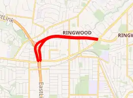
The Ringwood Bypass is a short stretch of road extending from EastLink to Maroondah Highway in Melbourne, Australia. It allows the Maroondah Highway to bypass Eastland, the main shopping centre in the eastern Melbourne suburb of Ringwood.
Ringwood Bypass | |
|---|---|
| |
  West end East end | |
| Coordinates |
|
| General information | |
| Type | Highway |
| Length | 2 km (1.2 mi)[1] |
| Opened | 1996 |
| Route number(s) |  State Route 62 (2008-present) State Route 62 (2008-present) |
| Major junctions | |
| West end |  EastLink EastLinkRingwood, Melbourne |
 Warrandyte Road Warrandyte Road | |
| East end | Mount Dandenong Road Ringwood, Melbourne |
| Highway system | |
Route
The bypass begins at the intersection with EastLink - with access to the Maroondah Highway west of Ringwood extended south from Eastlink's ramps - and heads east as an 8-lane, dual-carriageway road, adjacent to Mullum Mullum Creek, crossing Ringwood Street and Warrandyte Road, before ending at the intersection with the Maroondah Highway east of Ringwood and Mount Dandenong Road. The speed limit is 80 kilometres per hour (50 mph).
History
Originally known as the Eastern Freeway Extension, it was renamed the Ringwood Bypass to avoid connotations that it was part of a freeway network for accessing the CBD.[2] The first stage of the road began construction in January 1995[3] and opened in September 1996, starting at Mount Dandenong Road and heading west to Ringwood Street.[4] As part of the EastLink works, the road was extended by 1.5 km (0.93 mi) to connect to the Maroondah Highway and EastLink. In 2003 there was controversy about whether the bypass would be tolled, with the State Government making assurances that it would not be.[5]
The bypass was signed as State Route 62 along its entire length when the second stage opened at the same time as EastLink in 2008.
The passing of the Road Management Act 2004[6] granted the responsibility of overall management and development of Victoria's major arterial roads to VicRoads: in 2004, VicRoads re-declared the road as Ringwood Bypass (Arterial #6270), beginning at Ringwood Street and ending at Maroondah Highway through Ringwood;[7] the road west of Ringwood Street connects to EastLink, a private tollway not under the jurisdiction of VicRoads.
Major intersections
The entire bypass lies within the City of Maroondah local government area.
| Location[1][7] | km[1] | mi | Destinations | Notes | |
|---|---|---|---|---|---|
| Ringwood | 0.0 | 0.0 | EastLink (M3) – City, Dandenong, Frankston Maroondah Highway (State Route 34) – Nunawading, Box Hill Maroondah Highway (State Route 34) – Nunawading, Box Hill | Western terminus of bypass and State Route 62 at semi-directional T interchange | |
| 1.1 | 0.68 | Ringwood Street | Traffic light intersection | ||
| 1.4 | 0.87 | Warrandyte Road (State Route 9) – Warrandyte, Wantirna | Traffic light intersection | ||
| 2.0 | 1.2 | Maroondah Highway (State Route 34) – Lilydale, Yarra Glen, Healesville | Traffic light intersection | ||
| Mount Dandenong Road (State Route 62 east) – Croydon, Mount Dandenong | Eastern terminus of bypass, State Route 62 continues east along Mount Dandenong Road | ||||
1.000 mi = 1.609 km; 1.000 km = 0.621 mi
| |||||
See also
 Australian Roads portal
References
- Google (13 February 2014). "Ringwood Bypass" (Map). Google Maps. Google. Retrieved 13 February 2014.
- Public Transport Users Association. "Myth: The purpose of freeways is to bypass congested areas". www.ptua.org.au. Retrieved 17 July 2008.
- "VicRoads Annual Report 1994-95". VicRoads. Melbourne: Victorian Government Library Service. 26 September 1995. p. 8.
- "Koonung Mullum Forestway Association: Background". home.vicnet.net.au. Archived from the original on 9 April 2011. Retrieved 17 July 2008.
- "Vic Govt promises no toll for Ringwood Bypass". ABC News. www.abc.net.au. 31 October 2003. Retrieved 17 July 2008.
- State Government of Victoria. "Road Management Act 2004" (PDF). Government of Victoria. Archived (PDF) from the original on 19 October 2021. Retrieved 19 October 2021.
- VicRoads. "VicRoads – Register of Public Roads (Part A) 2015" (PDF). Government of Victoria. p. 965. Archived from the original on 1 May 2020. Retrieved 19 October 2021.