Mickleham Road, Melbourne
Mickleham Road is a secondary road located in Victoria, Australia, north of Melbourne.[2]
Mickleham Road | |
|---|---|
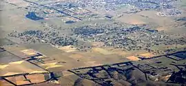 | |
Aerial photo looking south-east over Mickleham: Mickleham Road cuts across the bottom of this image | |
| |
  South end North end | |
| Coordinates |
|
| General information | |
| Type | Road |
| Length | 20.1 km (12 mi)[1] |
| Route number(s) |
|
| Former route number |
|
| Major junctions | |
| South end | Broadmeadows Road Tullamarine, Melbourne |
| |
| North end | Old Sydney Road Mickleham, Victoria |
| Location(s) | |
| LGA(s) | City of Hume |
| Major suburbs | Attwood, Greenvale, Yuroke, Mickleham |

Route
Mickleham Road begins at an intersection with Melrose Drive and Broadmeadows Road in Tullamarine, and continues north as a four-lane dual-carriageway road through the suburbs of Gladstone Park and under the Tullamarine Freeway, widening to a six-lane, dual-carriageway road to a large roundabout intersection with Broadmeadows Road in Westmeadows. It narrows back to a four-lane, dual-carriageway road and continues north through Attwood to the intersection with Somerton Road in Greenvale, where it narrows down to a two-lane, single-carriageway road. It continues north through Yuroke until reaching the intersection with Donnybrook Road in Mickleham, where it becomes Old Sydney Road (which continues north to Wallan; sections of Old Sydney Road are unsealed).
History
Mickleham Road was signed as State Route 39 between Melrose Drive in Tullamarine and Craigieburn Road in Yuroke, in 1989. With Victoria's conversion to the newer alphanumeric system in the late 1990s, the section between Greenvale and Mickleham was replaced by route C739.
The passing of the Road Management Act 2004[3] granted the responsibility of overall management and development of Victoria's major arterial roads to VicRoads: in 2004, VicRoads re-declared Mickleham Road (Arterial #5820) from Melrose Drive in Tullamarine to Donnybrook Road in Mickleham.[4]
Major intersections
Mickleham Road is entirely contained within the City of Hume.
| Location[1][4] | km[1] | mi | Destinations | Notes | ||
|---|---|---|---|---|---|---|
| Tullamarine | 0.0 | 0.0 | Broadmeadows Road – Tullamarine | Southern terminus of road, continues south as Broadmeadows Road | ||
 Melrose Drive (State Route 39 southeast, no shield northwest) – Airport West, Keilor Park Melrose Drive (State Route 39 southeast, no shield northwest) – Airport West, Keilor Park | Roundabout | |||||
| Westmeadows–Tullamarine–Gladstone Park tripoint | 1.0 | 0.62 |   Tullamarine Freeway (M2) – Docklands, Port Melbourne, Melbourne Airport Tullamarine Freeway (M2) – Docklands, Port Melbourne, Melbourne Airport | Concurrency with State Route 48 | ||
| Westmeadows–Gladstone Park boundary | 2.0 | 1.2 |  Broadmeadows Road (State Route 48) – Broadmeadows, Bundoora, Eltham Broadmeadows Road (State Route 48) – Broadmeadows, Bundoora, Eltham | |||
| Greenvale | 7.3 | 4.5 |  Somerton Road (State Route 58) – Oaklands Junction, Epping, South Morang Somerton Road (State Route 58) – Oaklands Junction, Epping, South Morang | Northern terminus of State Route 39, southern terminus of route C739 | ||
| Mickleham–Craigieburn–Yuroke tripoint | 12.4 | 7.7 |  Craigieburn Road (C722 east, no allocation west) – Craigieburn, Wollert Craigieburn Road (C722 east, no allocation west) – Craigieburn, Wollert | |||
| Mickleham | 15.6 | 9.7 | Mount Ridley Road – Craigieburn | |||
| 18.9 | 11.7 |  Donnybrook Road (C723) – Donnybrook, Yan Yean Donnybrook Road (C723) – Donnybrook, Yan Yean | ||||
| Old Sydney Road – Wallan | Northern terminus of road and route C739, road continues north as Old Sydney Road | |||||
| ||||||
See also
 Australian Roads portal




References
- Google (20 October 2021). "Mickleham Road" (Map). Google Maps. Google. Retrieved 20 October 2021.
- "Maps of declared roads". VicRoads. Retrieved 20 November 2021.
- State Government of Victoria. "Road Management Act 2004" (PDF). Government of Victoria. Archived (PDF) from the original on 19 October 2021. Retrieved 19 October 2021.
- VicRoads. "VicRoads – Register of Public Roads (Part A) 2015". Government of Victoria. p. 784. Archived from the original on 1 May 2020. Retrieved 19 October 2021.