N8 highway (Philippines)
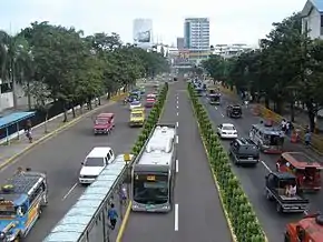
National Route 8 (N8) is a 174-kilometer (108 mi), two-six lane north-south major primary national route that forms part of the Philippine Highway Network in the province of Cebu. There are four highways that make up the road: the Cebu North Road, General Maxilom Avenue, Osmeña Boulevard and Natalio Bacalso Avenue. It runs from Danao to Santander.[1][2][3][4][5]
.svg.png.webp) | ||||
|---|---|---|---|---|
 | ||||
| Route information | ||||
| Maintained by Department of Public Works and Highways (DPWH) | ||||
| Length | 174 km (108 mi) | |||
| Major junctions | ||||
| North end | .svg.png.webp) N810 (Cebu North Road) in Danao N810 (Cebu North Road) in Danao | |||
| ||||
| South end | .svg.png.webp) N830 (Natalio Bacalso Avenue) in Santander N830 (Natalio Bacalso Avenue) in Santander | |||
| Location | ||||
| Provinces | Cebu | |||
| Major cities | Danao, Mandaue, Cebu, Talisay, Naga, Carcar | |||
| Towns | Compostela, Liloan, Consolacion, Minglanilla, San Fernando, Sibonga, Argao, Dalaguete, Alcoy, Boljoon, Oslob, Santander | |||
| Highway system | ||||
| ||||
.svg.png.webp)
.svg.png.webp)
History
When the national routes were added, four roads (Cebu North Road; Cebu City to Danao, General Maxilom Avenue, Osmeña Boulevard and Natalio Bacalso Avenue; Cebu City to Santander) assigned as National Route 8 (N8) by the Department of Public Works and Highways.
Route description
Danao to Cebu
The route starts at Cebu North Road from a route change from N810 and meets its northern terminus in Danao. It makes a junction on the under-construction Metro Cebu Expressway.[6]
Cebu City
The road meets its southern terminus and continues at General Maxilom Avenue in Cebu. The road ends in a roundabout and continues at Osmeña Boulevard. The boulevard ends at Natalio Bacalso Avenue and the route continues at the latter.
Intersections
Intersections are numbered by kilometer posts, with Cebu Provincial Capitol in Cebu City designated as kilometer 0.
| Region | Province | City/Municipality | km | mi | Destinations | Notes | |
|---|---|---|---|---|---|---|---|
| Central Visayas | Cebu | Danao | 33 | 21 | N810 (Cebu North Road) | Northern terminus from a route change. | |
| Danao | 32 | 20 | Metro Cebu Expressway | Under construction. Serves as diversion upon completion. | |||
| Liloan | 18 | 11 | .svg.png.webp) N840 (Consolacion–Tayud–Liloan Road) N840 (Consolacion–Tayud–Liloan Road) | Serves as diversion road. | |||
| Mandaue | 8 | 5.0 | .svg.png.webp) N841 (United Nations Avenue) N841 (United Nations Avenue) | ||||
| 7 | 4.3 | .svg.png.webp) N82 (AC Cortes Avenue) N82 (AC Cortes Avenue) | |||||
| Cebu City | 3 | 1.9 | .svg.png.webp) N815 (8th Street) N815 (8th Street) | ||||
| Cebu | Talisay | 9 | 5.6 | .svg.png.webp) N825 (Cebu–Toledo Wharf Road) N825 (Cebu–Toledo Wharf Road) | |||
| Talisay | 11 | 6.8 | N840 (Cebu South Coastal Road) | Serves as diversion road. | |||
| Naga | 21 | 13 | .svg.png.webp) N81 (Naga–Uling Road) N81 (Naga–Uling Road) | ||||
| Carcar | 39 | 24 | N830 (Carcar–Barili–Mantapuyan Road) | roundabout | |||
| Santander | 141 | 88 | N830 (Natalio Bacalso Avenue) | Southern terminus in a route change. | |||
1.000 mi = 1.609 km; 1.000 km = 0.621 mi
| |||||||
See also
References
- "Cebu 2nd". www.dpwh.gov.ph. Retrieved 2021-04-26.
- "Cebu 4th". www.dpwh.gov.ph. Retrieved 2021-04-26.
- "Cebu 5th". www.dpwh.gov.ph. Retrieved 2021-04-26.
- "Cebu 6th". www.dpwh.gov.ph. Retrieved 2021-04-26.
- "Cebu City". www.dpwh.gov.ph. Retrieved 2021-04-26.
- "Road and Bridge Inventory | Department of Public Works and Highways". www.dpwh.gov.ph. Retrieved 2021-05-20.
External Links
Department of Public Works and Highways
| National primary roads |
|  | ||||||
|---|---|---|---|---|---|---|---|---|
| National secondary roads |
| |||||||
See also: Philippine expressway network | ||||||||