Bellarine Highway
The Bellarine Highway[2] runs east from Geelong in Victoria along the Bellarine Peninsula to Queenscliff.
Bellarine Highway | |
|---|---|
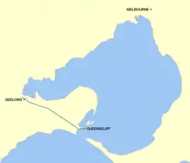 | |
Map of the Bellarine Highway, south-west of Port Phillip Bay | |
| General information | |
| Type | Highway |
| Length | 33 km (21 mi)[1] |
| Route number(s) |  B110 (1998-present) B110 (1998-present)Entire route (via McKillop Street) |
| Former route number |  State Route 91 (1986-1998) State Route 91 (1986-1998)Entire route (via Ryrie Street) |
| Major junctions | |
| West end |  Princes Highway Princes HighwayGeelong, Victoria |
| |
| East end | Wharf Street East Queenscliff, Victoria |
| Location(s) | |
| Major settlements | Thomson, Newcomb, Moolap, Leopold, Wallington, Point Lonsdale |
| Highway system | |
The highway provides the main route to Leopold, and Ocean Grove to the highway's south. The road has been progressively duplicated as far as Grubb Road. The highway ends at Wharf Street, Queenscliff, where it meets the Peninsula Searoad Transport passenger and motor vehicle ferry which operates across Port Phillip Bay to Sorrento on the Mornington Peninsula.
History
The passing of the Highways and Vehicles Act of 1924[3] through the Parliament of Victoria provided for the declaration of State Highways, roads two-thirds financed by the State government through the Country Roads Board (later VicRoads). The Bellarine Highway was declared a State Highway in the 1947/48 financial year,[4] from Geelong to Queenscliff (for a total of 20 miles); before this declaration, the road was referred to as Geelong-Queenscliffe Road.[5] It was named after the Bellarine peninsula.
The Bellarine Highway was signed as State Route 91 between Geelong and Queenscliff in 1986;[6] with Victoria's conversion to the newer alphanumeric system in the late 1990s, this was replaced by route B110, which continues on the other side of the bay at Sorrento to run along Point Nepean Road until Mornington. The Geelong end of the highway originally ran along Ryrie Street in the Geelong city centre, but was relocated a number of blocks south to Mackillop Street to remove heavy trucks from the shopping district when the route was replaced.
Major intersections
| LGA | Location | km[1] | mi | Destinations | Notes |
|---|---|---|---|---|---|
| Greater Geelong | Geelong | 0 | 0.0 | Latrobe Terrace (Princes Highway) (A10) – Melbourne, Avalon, Colac | Western terminus of highway (as McKillop Street) and route B110 |
| East Geelong | 2.1 | 1.3 | Ormond Street (north-west) – Central Geelong McKillop Street (east) – East Geelong | Eastbound traffic turns south-east onto Ormond Street, westbound traffic turns west onto McKillop Street | |
| Thomson–Newcomb–East Geelong tripoint | 3.6 | 2.2 |  Boundary Road (C124) – Belmont, Grovedale, Whittington Boundary Road (C124) – Belmont, Grovedale, Whittington | Eastbound traffic continues east onto Bellarine Highway, westbound traffic continues north-west onto Ormond Street | |
| Wallington | 18.9 | 11.7 |  Grubb Road (C129) – Drysdale, Ocean Grove, Barwon Heads Grubb Road (C129) – Drysdale, Ocean Grove, Barwon Heads | Roundabout | |
| Queenscliffe | Point Lonsdale | 25.9 | 16.1 |  Portarlington–Queenscliff Road (C126) – Portarlington Portarlington–Queenscliff Road (C126) – Portarlington | |
| Point Lonsdale–Queenscliff boundary | 27.8 | 17.3 |  Point Lonsdale Road (C127) – Point Lonsdale Point Lonsdale Road (C127) – Point Lonsdale | Roundabout | |
| Queenscliff | 32.5 | 20.2 | Wharf Street East | Eastern terminus of highway Route B110 continues via Queenscliff–Sorrento Ferry to Point Nepean Road, Sorrento | |
1.000 mi = 1.609 km; 1.000 km = 0.621 mi
| |||||
References
- Google (13 April 2014). "Bellarine Highway" (Map). Google Maps. Google. Retrieved 13 April 2014.
- Bellarine Highway, Point Nepean Road, & Mornington Peninsula Freeway (B110), Expressway - Paul Rands. Retrieved on 8 September 2013.
- State of Victoria, An Act to make further provision with respect to Highways and Country Roads Motor Cars and Traction Engines and for other purposes 30 December 1924
- "Country Roads Board Victoria. Thirty-Fifth Annual Report: for the year ended 30 June 1948". Country Roads Board of Victoria. Melbourne: Victorian Government Library Service. 1 November 1948. p. 7.
- "Country Roads Board Victoria. Twenty-Sixth Annual Report: for the year ended 30 June 1939". Country Roads Board of Victoria. Melbourne: Victorian Government Library Service. 10 November 1939. p. 87.
- "Road Construction Authority of Victoria. Annual Report for the year ended 30 June 1986". Road Construction Authority of Victoria. Melbourne: Victorian Government Library Service. 24 November 1986. p. 42.
 Road infrastructure in Geelong Road infrastructure in Geelong | ||
|---|---|---|
 | ||