Henty Highway
Henty Highway[2] is a 359 kilometre highway in western Victoria, Australia. It is primarily a north-south route, and consists of a mix of 2-laned country highway standard and 4-lane arterial road within some of the larger towns along the route. It was named in honour of Edward Henty, a British colonist regarded as the first permanent European settler of the Port Phillip District (in what later became the Colony of Victoria), in the town eventually named Portland.
Henty Highway | |
|---|---|
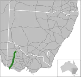 | |
Map of south-eastern Australia with Henty Highway highlighted in green | |
| General information | |
| Type | Highway |
| Length | 359 km (223 mi)[1] |
| Opened | 1938 |
| Route number(s) |
|
| Former route number |  State Route 107 (1986-1998) State Route 107 (1986-1998) |
| Major junctions | |
| North end |  Sunraysia Highway Sunraysia HighwayLascelles, Victoria |
| South end |  Madeira Packet Road Madeira Packet RoadPortland, Victoria |
| Location(s) | |
| Major settlements | Hopetoun, Warracknabeal, Horsham, Hamilton, Heywood |
| Highway system | |


History
The passing of the Highways and Vehicles Act of 1924[3] through the Parliament of Victoria provided for the declaration of State Highways, roads two-thirds financed by the State government through the Country Roads Board (later VicRoads). The Henty Highway was declared a State Highway in August 1938,[4] cobbled together from roads between Mildura, Warracknabeal, Horsham, and Hamilton to Portland (for a total of 263 miles); before this declaration, these roads were referred to as Mildura Road, Hopetoun(-Lascelles) Road, Hopetoun-Warracknabeal Road, Hamilton-Horsham Road and Hamilton-Portland Road.[5] It originally started from the Calder Highway in Nunga, the junction south of Ouyen; when the North-Western Highway was renamed Sunraysia Highway on 11 September 1972, and extended from Lascelles to Nunga, the Henty Highway was truncated back to Lascelles.[6]
The Henty Highway was signed as State Route 107 between Portland and Lascelles in 1986;[7] with Victoria's conversion to the newer alphanumeric system in the late 1990s, this was replaced by route A200 between Portland and Horsham, and B200 between Horsham and Lascelles.
The passing of the Road Management Act 2004[8] granted the responsibility of overall management and development of Victoria's major arterial roads to VicRoads: in 2013, VicRoads re-declared the road as Henty Highway (Arterial #6620) between the Sunraysia Highway in Lascelles) and Madeira Packet Road at Portland.[9]
Upgrades
- 1949 – 8 mile deviation of the Henty Highway as a result of proposed inundation following the construction of the Rocklands Reservoir dam on the Glenelg River, between Cavendish and Cherrypool.[10]
Major intersections and towns
| LGA | Location | km[1] | mi | Destinations | Notes |
|---|---|---|---|---|---|
| Glenelg | Portland | 0.0 | 0.0 | Madeira Packet Road (C194 east) – Port area Henty Highway Link Road (south) – South Portland | Southern terminus of highway and route A200 |
| 2.4 | 1.5 | Madeira Packet Road (C194) – South Portland | |||
| 3.7 | 2.3 |  Bridgewater Road (C193 west) – Portland West, Cape Bridgewater Bridgewater Road (C193 west) – Portland West, Cape BridgewaterOtway Street (east) – Portland | |||
| 4.7 | 2.9 |  Portland-Nelson Road (C192) – Nelson Portland-Nelson Road (C192) – Nelson | |||
| 6.1 | 3.8 | New Street – Portland | |||
| Bolwarra | 8.7 | 5.4 |  Princes Highway (A1 east) – Warrnambool Princes Highway (A1 east) – Warrnambool | Concurrency with route A1 | |
| Heywood | 29.5 | 18.3 |   Woolsthorpe-Heywood Road (C176/C191) – Woolsthorpe, Warrnambool Woolsthorpe-Heywood Road (C176/C191) – Woolsthorpe, Warrnambool | ||
| 30.0 | 18.6 | Princes Highway (A1 west) – Mount Gambier | |||
| Myamyn | 46 | 29 |  Myamin-Macarthur Road (C186) – Macarthur Myamin-Macarthur Road (C186) – Macarthur | ||
| Southern Grampians | Hamilton | 86.5 | 53.7 |  Hamilton-Port Fairy Road (C184) – Port Fairy Hamilton-Port Fairy Road (C184) – Port Fairy | |
| 87.5 | 54.4 |  Dartmoor-Hamilton Road (C187) – Dartmoor Dartmoor-Hamilton Road (C187) – Dartmoor | |||
| 88.3 | 54.9 |  Glenelg Highway (B160 east) – Ballarat, Geelong Glenelg Highway (B160 east) – Ballarat, Geelong | Concurrency with route B160 | ||
| 90.6 | 56.3 | Glenelg Highway (B160 west) – Casterton, Mount Gambier | |||
| Cavendish | 113 | 70 |  Dunkeld-Cavendish Road (C188 northwest) – Dunkeld Dunkeld-Cavendish Road (C188 northwest) – Dunkeld | Concurrency with route C188 | |
| 114 | 71 | Natimuk-Hamilton Road (C188 southeast) – Balmoral | |||
| Horsham | Horsham | 215 | 134 |  Western Highway (A8 east) – Ararat, Ballarat, Melbourne Western Highway (A8 east) – Ararat, Ballarat, Melbourne | Southern terminus of concurrency with route A8 |
| 216 | 134 |  Horsham-Lubeck Road (C215) – Longerenong, Lubeck Horsham-Lubeck Road (C215) – Longerenong, Lubeck | |||
| Wimmera River | |||||
| 217 | 135 |  Wimmera Highway (B240 west) – Edenhope, Naracoorte Wimmera Highway (B240 west) – Edenhope, Naracoorte | Southern terminus of concurrency with route B240 | ||
| 218 | 135 | Western Highway (A8 west) – Dimboola, Bordertown, Adelaide | Northern terminus of concurrency with route A8 Route transistion: route A200 south, route B200 north | ||
| Dooen | 227 | 141 | Wimmera Highway (B240 east) – Murtoa, St Arnaud, Bendigo | Northern terminus of concurrency with route B240 | |
| Byrneville | 244 | 152 |  Horsham-Minyip Road (C236) – Minyip, Donald Horsham-Minyip Road (C236) – Minyip, Donald | ||
| Yarriambiack | Warracknabeal | 274 | 170 |  Stawell-Warracknabeal Road (B210) – Stawell, Melbourne Stawell-Warracknabeal Road (B210) – Stawell, Melbourne | |
 Borung Highway (C234 west) – Dimboola Borung Highway (C234 west) – Dimboola | Concurrency with route C234 | ||||
| 275 | 171 |  Warracknabeal-Rainbow Road (C245 west) – Rainbow Borung Highway (C234 east) – Donald, Charlton Warracknabeal-Rainbow Road (C245 west) – Rainbow Borung Highway (C234 east) – Donald, Charlton | |||
| Beulah | 309 | 192 |  Birchip-Rainbow Road (C243) – Birchip, Rainbow Birchip-Rainbow Road (C243) – Birchip, Rainbow | ||
| Hopetoun | 334 | 208 |  Hopetoun-Rainbow Road (C227) – Rainbow Hopetoun-Rainbow Road (C227) – Rainbow | ||
| 338 | 210 |  Hopetoun-Walpeup Road (C247) – Walpeup Hopetoun-Walpeup Road (C247) – Walpeup | |||
| 342 | 213 |  Hopetoun-Sea Lake Road (C246) – Sea Lake Hopetoun-Sea Lake Road (C246) – Sea Lake | |||
| Lascelles | 359 | 223 | Sunraysia Highway (B220) – Ouyen, Mildura | Northern terminus of highway and route B200 | |
1.000 mi = 1.609 km; 1.000 km = 0.621 mi
| |||||
References
- Google (18 October 2021). "Henty Highway" (Map). Google Maps. Google. Retrieved 18 October 2021.
- Henty Highway (A/B200), Expressway - Paul Rands. Retrieved on 14 September 2013.
- State of Victoria, An Act to make further provision with respect to Highways and Country Roads Motor Cars and Traction Engines and for other purposes 30 December 1924
- "Country Roads Board Victoria. Twenty-Sixth Annual Report: for the year ended 30 June 1939". Country Roads Board of Victoria. Melbourne: Victorian Government Library Service. 10 November 1939. p. 4.
- "Country Roads Board Victoria. Twenty-First Annual Report: for the year ended 30 June 1934". Country Roads Board of Victoria. Melbourne: Victorian Government Library Service. 19 November 1934. pp. 68, 70, 72.
- "Country Roads Board Victoria. Sixtieth Annual Report: for the year ended 30 June 1973". Country Roads Board of Victoria. Melbourne: Victorian Government Library Service. 1 November 1973. p. 14.
- "Road Construction Authority of Victoria. Annual Report for the year ended 30 June 1986". Road Construction Authority of Victoria. Melbourne: Victorian Government Library Service. 24 November 1986. p. 42.
- State Government of Victoria. "Road Management Act 2004" (PDF). Government of Victoria. Archived (PDF) from the original on 19 October 2021. Retrieved 19 October 2021.
- VicRoads. "VicRoads – Register of Public Roads (Part A) 2015" (PDF). Government of Victoria. pp. 1003–4. Archived from the original on 1 May 2020. Retrieved 19 October 2021.
- "Country Roads Board Victoria. Thirty-Sixth Annual Report: for the year ended 30 June 1949". Country Roads Board of Victoria. Melbourne: Victorian Government Library Service. 1 November 1949. p. 14.
