Mallee Highway
The Mallee Highway[2][3][4] (formerly the Ouyen Highway in Victoria) is part of the shortest route between Adelaide and Sydney. It runs east from Tailem Bend in South Australia through cereal-growing farmland at the southern end of the Murray Mallee to Pinnaroo near the border with Victoria, where it crosses Pinnaroo-Loxton and Pinnaroo-Bordertown Road in Pinnaroo. It continues in Victoria through Ouyen, where it crosses the Calder Highway, via Manangatang to Piangil, where it meets with the Murray Valley Highway.
Mallee Highway –Victoria | |
|---|---|
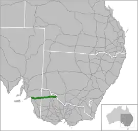 | |
| General information | |
| Type | Highway |
| Length | 374 km (232 mi)[1] |
| Route number(s) |  B12 (1997/8–present) B12 (1997/8–present) |
| Former route number |  National Route 12 (1955–1997/8) National Route 12 (1955–1997/8) |
| Major junctions | |
| West end |  Dukes Highway Dukes HighwayTailem Bend, South Australia |
| East end | Tooleybuc Road VIC/NSW border |
| Location(s) | |
| Major settlements | Lameroo, Pinnaroo, Murrayville, Walpeup, Ouyen, Manangatang |
| Highway system | |
Route B12, however continues past the Mallee Highway terminus along the Murray Valley Highway for two kilometres north of Piangil, linking to Tooleybuc Road where it continues until it crosses the New South Wales border and the Murray River at Tooleybuc. The road then continues to Balranald, at the Murrumbidgee River (without the B12 designation). Tooleybuc Road terminates at the Sturt Highway which continues en route to Sydney via the Hume Highway or Mid-Western Highway.
History
The passing of the Highways and Vehicles Act of 1924[5] through the Parliament of Victoria provided for the declaration of State Highways, roads two-thirds financed by the State government through the Country Roads Board (later VicRoads). The Ouyen Highway was declared a State Highway within Victoria in the 1947/48 financial year,[6] from the Calder Highway at Ouyen via Murrayville to the South Australian border (for a total of 81 miles); before this declaration, the roads were referred to as Ouyen-Pinnaroo Road.[7] The name was later changed to the Malee Highway and extended to the Murray Valley Highway in Piangil in 1991.
The highway was signed as National Route 12 between Tailem Bend and Ouyen in 1955, later extended to Piangil in 1991. With both states' conversion to their newer alphanumeric systems in the late 1990s, its former route number was updated to B12 in 1997 (within Victoria) and in 1998 (in South Australia).
The passing of the Road Management Act 2004[8] granted the responsibility of overall management and development of Victoria's major arterial roads to VicRoads: in 2004, VicRoads re-declared the road as Mallee Highway (Arterial #6650), beginning at the South Australian border at Panitya and ending at the New South Wales border in Piangil.[9]
Major intersections and towns
| State | LGA | Location[1][9] | km[1] | mi | Destinations | Notes |
|---|---|---|---|---|---|---|
| South Australia | The Coorong | Tailem Bend | 0.0 | 0.0 | Dukes Highway (A8) – Adelaide, Keith, Bordertown, Melbourne | Western terminus of highway and route B12 |
| Moorlands | 14.5 | 9.0 | Old Dukes Highway – Coomandook | |||
| Sherlock | 29.7 | 18.5 | Kulkawurra Road (north) – Karoonda Tynan Road (south) – Yumali | |||
| Southern Mallee | Lameroo | 98.5 | 61.2 | Billiat Road – Alawoona | Roundabout | |
| Pinnaroo | 132.7 | 82.5 |  Ngarkat Highway (B57 south) – Bordertown, Naracoorte Ngarkat Highway (B57 south) – Bordertown, Naracoorte | Concurrency with route B57 | ||
| 139.3 | 86.6 | Browns Well Highway (B57 north) – Loxton, Renmark | ||||
| State border | 145.0 | 90.1 | South Australia – Victoria state border | |||
| Victoria | Mildura | Panitya | 148.4 | 92.2 | Panitya Road – Panitya | |
| Murrayville | 166.4 | 103.4 | Murrayville-Nhill Road – Nhill | |||
| Boinka | 205.9 | 127.9 | Boinka South Road – Tutye | |||
| Underbool | 226.3 | 140.6 | Underbool-Patchewollock Road – Patchewollock | |||
| Walpeup | 246.1 | 152.9 |  Walpeup-Patchewollock Road (C247) – Patchewollock, Hopetoun Walpeup-Patchewollock Road (C247) – Patchewollock, Hopetoun | |||
| Ouyen | 273.0 | 169.6 | Ouyen-Patchewollock Road – Patchewollock, Hopetoun | |||
| 275.3 | 171.1 |  Calder Highway (A79 south) – Ballarat, Bendigo, Melbourne Calder Highway (A79 south) – Ballarat, Bendigo, Melbourne | Concurrency with route A79 | |||
| 275.5 | 171.2 | Calder Highway (A79 north) – Red Cliffs, Mildura | ||||
| Swan Hill | Manangatang | 330.0 | 205.1 |  Robinvale–Sea Lake Road (C251) – Robinvale, Sea Lake Robinvale–Sea Lake Road (C251) – Robinvale, Sea Lake | ||
| Piangil | 371.1 | 230.6 |  Murray Valley Highway (B400 south) – Swan Hill, Melbourne Murray Valley Highway (B400 south) – Swan Hill, Melbourne | Concurrency with route B12 | ||
| 373.0 | 231.8 | Murray Valley Highway (B400 north) – Robinvale | ||||
| 374.4 | 232.6 | Tooleybuc Road – Tooleybuc, Balranald | Eastern terminus of highway and route B12; road continues as Yanga Way to Balranald | |||
| State border | Victoria – New South Wales state border | |||||
| New South Wales | Murray River | Tooleybuc Bridge | ||||
1.000 mi = 1.609 km; 1.000 km = 0.621 mi
| ||||||
See also
References
- Google (12 October 2021). "Mallee Highway" (Map). Google Maps. Google. Retrieved 12 October 2021.
- Mallee Highway Touring Route, Design Train. Retrieved on 15 September 2013.
- National Routes – Interstate Links, Main Roads Victoria. Retrieved on 15 September 2013.
- B12 Mallee Highway, Ozroads. Retrieved on 15 September 2013.
- State of Victoria, An Act to make further provision with respect to Highways and Country Roads Motor Cars and Traction Engines and for other purposes 30 December 1924
- "Country Roads Board Victoria. Thirty-Fifth Annual Report: for the year ended 30 June 1948". Country Roads Board of Victoria. Melbourne: Victorian Government Library Service. 1 November 1948. p. 7.
- "Country Roads Board Victoria. Twenty-Sixth Annual Report: for the year ended 30 June 1939". Country Roads Board of Victoria. Melbourne: Victorian Government Library Service. 10 November 1939. p. 99.
- State Government of Victoria. "Road Management Act 2004" (PDF). Government of Victoria. Archived (PDF) from the original on 19 October 2021. Retrieved 19 October 2021.
- VicRoads. "VicRoads – Register of Public Roads (Part A)" (PDF). Government of Victoria. p. 992. Archived from the original on 1 May 2020. Retrieved 19 October 2021.
External links
 Media related to Mallee Highway at Wikimedia Commons
Road infrastructure in South Australia | ||
|---|---|---|
| Expressways |
|  |
| Interstate highways | ||
| State highways | ||
| Arterial roads |
| |
| Outback tracks | ||