Great Alpine Road
The Great Alpine Road (B500)[2][3] is a country tourist road in Victoria, Australia, running from Wangaratta in the north to Bairnsdale in the east, and passing through the Victorian Alps. The road was given its current name because it was considered the mountain equivalent to Victoria's world-famous Great Ocean Road in the south-west of the state. The road usually remains open during winter; however, vehicles travelling between Harrietville and Omeo are required to carry diamond-pattern[4] snow chains during the declared snow season.[5]
Great Alpine Road | |
|---|---|
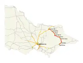 | |
Map of the Great Alpine Road in eastern Victoria | |
| General information | |
| Type | Highway |
| Length | 304 km (189 mi)[1] |
| Opened | 1998 |
| Route number(s) |  B500 (1996–present) B500 (1996–present) |
| Former route number |
|
| Major junctions | |
| Northwest end |  Old Hume Highway Old Hume HighwayWangaratta, Victoria |
| |
| Southeast end |  Princes Highway Princes HighwayBairnsdale, Victoria |
| Location(s) | |
| Major settlements | Myrtleford, Ovens, Bright, Harrietville, Mount Hotham, Dinner Plain, Omeo, Swifts Creek, Ensay}, Bruthen |
| Highway system | |


History
In 1923 the Victorian Country Roads Board (CRB) took responsibility for the Alpine Road between Harrietville and Omeo, and appointed William Benjamin (Bill) Spargo (1888–1959) as supervisor.[6] He lived in a stone cottage at Hotham Heights, which the CRB expanded, at his request, to accommodate up to twenty visiting skiers. From 1925 the premises operated as a guest-house, Hotham Cottage (Hotham Heights Chalet). This was the forerunner of the Hotham Alpine Resort.
The passing of the Highways and Vehicles Act of 1924[7] through the Parliament of Victoria provided for the declaration of State Highways, roads two-thirds financed by the State government through the Country Roads Board (later VicRoads). The Ovens Highway was declared a State Highway within Victoria in the 1947/48 financial year,[8] from Wangaratta via Myrtleford to Bright (for a total of 47.5 miles); before this declaration, the road was referred to as (The) Alpine Road.[9]
The Ovens Highway, and the remainder of Alpine Road beyond, was signed as State Route 156 between Wangaratta and Omeo in 1986. With Victoria's conversion to the newer alphanumeric system in the late 1990s, its former route number was replaced with route B500 in late 1996. The Ovens Highway and Alpine Road from Wangaratta to Omeo, and the southern section of the Omeo Highway from Omeo to Bruthen[10] and then to Bairnsdale, were declared the Great Alpine Road in 1998.
Route details
The Great Alpine Road[11] winds through mountains, valleys and forests, and past rivers, vineyards and farms. At a length of 304 kilometres (189 mi), it is Australia's highest year-round accessible sealed road. The section over Mount Hotham rises to an altitude of 1,840 metres (6,040 ft) AMSL.[12] It is blanketed with snow during winter months and must be cleared on a daily basis. Extreme weather conditions can sometimes still result in the road being closed between Harrietville and Omeo.
The Great Alpine Road links Victoria's North East with Gippsland. It was completed with the sealing of the section between Mount Hotham and Dinner Plain and was officially opened on 4 April 1998. The road itself has existed since colonial times in some form, but was unsealed for much of its history, and was only given the Great Alpine Road designation after being fully sealed.
Gallery of some notable sights
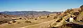 The Great Alpine Road descending "The Gap" between Omeo and Swifts Creek.
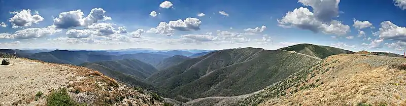 The Australian Alps from the Great Alpine Road on Mount Hotham.
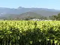 View from Myrtleford to Mount Buffalo National Park.
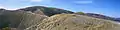 The Great Alpine Road winds across Mount Hotham, clinging to the side and ridge of the mountain
Major intersections, towns and resorts
| LGA | Location | km[1] | mi | Destinations | Notes |
|---|---|---|---|---|---|
| Wangaratta | Wangaratta | 0.0 | 0.0 | Parfitt Road – Wangaratta, Yarrawonga, Wodonga | Northwestern terminus of road and route B500 |
| East Wangaratta | 4.2 | 2.6 |  Hume Highway – Melbourne, Seymour, Wodonga, Sydney Hume Highway – Melbourne, Seymour, Wodonga, Sydney | ||
| Tarrawingee | 11.0 | 6.8 |  Beechworth-Wangaratta Road (C315) – Beechworth, Yackandandah Beechworth-Wangaratta Road (C315) – Beechworth, Yackandandah | ||
| Bowmans Forest | 33.7 | 20.9 |  Buckland Gap Road (C524) – Beechworth Buckland Gap Road (C524) – Beechworth | ||
| Alpine | Gapsted | 39.4 | 24.5 |  Snow Road – Milawa, Glenrowan Snow Road – Milawa, Glenrowan | |
| Myrtleford | 44.8 | 27.8 |  Myrtleford-Yackandandah Road (C527) – Yackandandah Myrtleford-Yackandandah Road (C527) – Yackandandah | ||
| 45.2 | 28.1 |  Buffalo River Road (C526) – Lake Buffalo Buffalo River Road (C526) – Lake Buffalo | |||
| Ovens | 50.1 | 31.1 |  Happy Valley Road (C534) – Mount Beauty Happy Valley Road (C534) – Mount Beauty | ||
| Porepunkah | 69.9 | 43.4 |  Mount Buffalo Road (C535) – Mount Buffalo Mount Buffalo Road (C535) – Mount Buffalo | Roundabout | |
| Bright | 75.7 | 47.0 | Anderson Street – Bright, to Morses Creek Road – Wandiligong | ||
| Germantown | 81.3 | 50.5 |  Tawonga Gap Road (C536) – Mount Beauty Tawonga Gap Road (C536) – Mount Beauty | ||
| Harrietville | 100.7 | 62.6 | Mill Road – Harrietville | ||
| Hotham Heights | 121.0 | 75.2 | Dargo High Plains Road – Dargo, Bairnsdale | Summer season only road | |
| Mount Hotham | 132.4 | 82.3 | Davenport Drive – Mount Hotham | ||
| Dinner Plain | 142.2 | 88.4 | Horseshoe Circuit – Dinner Plain | ||
| Cobungra | 152.5 | 94.8 |  Mount Hotham Airport Road – Mount Hotham Airport Mount Hotham Airport Road – Mount Hotham Airport | ||
| East Gippsland | Omeo | 182.7 | 113.5 | Cassilis Road – Cassilis | |
| 186.3 | 115.8 |  Omeo Highway (C543) – Benambra, Tallangatta Omeo Highway (C543) – Benambra, Tallangatta | |||
| Swifts Creek | 211.9 | 131.7 | Cassilis Road – Cassilis | ||
| Ensay | 230.9 | 143.5 | Ensay-Doctors Flat Road – Ensay | ||
| Bruthen | 281.2 | 174.7 |  Bruthen-Nowa Nowa Road (C620) – Buchan, Orbost Bruthen-Nowa Nowa Road (C620) – Buchan, Orbost | ||
| Wiseleigh | 284.5 | 176.8 |  Sarsfield-Tambo Upper Road (C605) – Swan Reach Sarsfield-Tambo Upper Road (C605) – Swan Reach | ||
| Lucknow | 303.7 | 188.7 | Princes Highway (A1) – Lakes Entrance, Orbost, Bairnsdale, Melbourne | Roundabout; southeastern terminus of road and route B500 | |
1.000 mi = 1.609 km; 1.000 km = 0.621 mi
| |||||
References
- Google (10 October 2021). "Great Alpine Road" (Map). Google Maps. Google. Retrieved 10 October 2021.
- "Map NE Victoria" (PDF). Vic Roads. p. 16. Archived from the original (PDF) on 9 August 2008. Retrieved 9 February 2009.
- State Route 156 – Ovens Highway, Main Roads Victoria. Retrieved on 23 September 2013.
- Mount Hotham, Wheel Chains
- Travel Victoria, Great Alpine Road
- Garden, Donald S (2002). "Spargo, William Benjamin (Bill) (1888–1959)". Australian Dictionary of Biography. Retrieved 23 September 2019.
- State of Victoria, An Act to make further provision with respect to Highways and Country Roads Motor Cars and Traction Engines and for other purposes 30 December 1924
- "Country Roads Board Victoria. Thirty-Fifth Annual Report: for the year ended 30 June 1948". Country Roads Board of Victoria. Melbourne: Victorian Government Library Service. 1 November 1948. p. 7.
- "Country Roads Board Victoria. Twenty-Sixth Annual Report: for the year ended 30 June 1939". Country Roads Board of Victoria. Melbourne: Victorian Government Library Service. 10 November 1939. p. 105.
- 8423 Omeo, Victoria, Topographic Map. National Topographic Map Series (1 ed.). Commonwealth of Australia. 1982.
- "Great Alpine Road". Tourism Victoria. Retrieved 10 February 2009.
- "Mt Hotham Section". 2009 Google – Map data 2009 MapData Sciences Pty Ltd, PSMA. Retrieved 10 February 2009.
External links
 |
Wikimedia Commons has media related to Great Alpine Road. |
 |
Wikivoyage has a travel guide for Great Alpine Road. |
"Great Alpine Road – Tourism Victoria". Retrieved 21 July 2011.
"Australian Traveller". Retrieved 10 February 2009.
"Great Alpine Road – Visit Victoria (official tourism website)". Retrieved 20 June 2015.
"Sydney – Melbourne Touring". Archived from the original on 23 February 2009. Retrieved 10 February 2009.
"Victoria's Alpine High Country". Retrieved 10 February 2009.
"NRMA Motoring Services". Retrieved 10 February 2009.
"Discover East Gippsland". Archived from the original on 25 April 2009. Retrieved 10 February 2009.
