Pyrenees Highway, Victoria
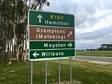
Pyrenees Highway in western Victoria, Australia is a 205-kilometre-long highway linking the Calder Highway in Elphinstone with the Glenelg Highway in Glenthompson. It intersects with the region's major road freight route, the Western Highway in Ararat, in addition to the Midland Highway in Castlemaine and Sunraysia Highway in Avoca. It was named after the Pyrenees ranges the highway runs through.
Pyrenees Highway | |
|---|---|
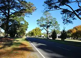 | |
Pyrenees Highway at Elmhurst | |
| General information | |
| Type | Highway |
| Length | 205 km (127 mi)[1] |
| Opened | 1938 |
| Route number(s) |  B180 (1998-present) B180 (1998-present) |
| Former route number |  State Route 122 (1986-1998) State Route 122 (1986-1998) |
| Major junctions | |
| East end |  Calder Freeway Calder FreewayElphinstone, Victoria |
| West end |  Glenelg Highway Glenelg HighwayGlenthompson, Victoria |
| Location(s) | |
| Major settlements | Chewton, Castlemaine, Newstead, Maryborough, Avoca, Amphitheatre, Ararat, Willaura |
| Highway system | |


In 1855, the Victorian Parliament passed the Chinese Immigration Act 1855, severely limiting the number of Chinese passengers permitted on an arriving vessel. To evade the new law, ship's captains landed many Chinese in the south-east of South Australia, from where the new arrivals travelled more than 400 km across country to the Victorian goldfields, along tracks including what is now the Pyrenees Highway.[2][3]
History
The passing of the Highways and Vehicles Act of 1924[4] through the Parliament of Victoria provided for the declaration of State Highways, roads two-thirds financed by the State government through the Country Roads Board (later VicRoads). The Pyrenees Highway was declared a State Highway in August 1938,[5] cobbled together from roads between the Calder Highway at Castlemaine, via Maryborough and Avoca to Ararat (for a total of 92.5 miles); before this declaration, these roads were referred to as Castlemaine-Maryborough Road, Maryborough-Avoca Road and Avoca-Ararat Road.[6] With the deviation of the Calder Highway past Castlemaine declared in the 1959/60 financial year,[7] the previous alignment of the Calder Highway between Castlemaine and Elphinstone was also added to the Pyrenees Highway. Its western end was later extended from Ararat to Glenthompson in the 1990s.
The Pyrenees Highway was signed as State Route 122 between Elphinstone and Ararat in 1986; with Victoria's conversion to the newer alphanumeric system in the late 1990s, this was replaced by route B180 between Elphinstone and Glenthompson.
See also
 Australian Roads portal
References
- Google (13 October 2021). "Pyrenees Highway, Victoria" (Map). Google Maps. Google. Retrieved 13 October 2021.
- "Chinese Immigration Act 1855 (Vic)". Documenting a Democracy. Museum of Australian Democracy. Retrieved 6 November 2013.
- "The Chinese Trek to Gold" (PDF). Australian Heritage. Archived from the original (PDF) on 23 March 2015. Retrieved 6 November 2013.
- State of Victoria, An Act to make further provision with respect to Highways and Country Roads Motor Cars and Traction Engines and for other purposes 30 December 1924
- "Country Roads Board Victoria. Twenty-Sixth Annual Report: for the year ended 30 June 1939". Country Roads Board of Victoria. Melbourne: Victorian Government Library Service. 10 November 1939. p. 4.
- "Country Roads Board Victoria. Twenty-First Annual Report: for the year ended 30 June 1934". Country Roads Board of Victoria. Melbourne: Victorian Government Library Service. 19 November 1934. pp. 92, 98, 102.
- "Country Roads Board Victoria. Forty-Seventh Annual Report: for the year ended 30 June 1960". Country Roads Board of Victoria. Melbourne: Victorian Government Library Service. 21 November 1960. pp. 7–8.
External links
 Media related to Pyrenees Highway at Wikimedia Commons
