Midland Highway (Victoria)
The Midland Highway is a major rural highway linking major towns in Victoria, beginning from Geelong and winds through country Victoria in a large arc through the towns of Ballarat, Bendigo and Shepparton, eventually reaching Mansfield at the foothills of the Victorian Alps.
Midland Highway | |
|---|---|
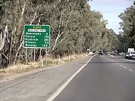 | |
Midland Highway at Shepparton | |
| General information | |
| Type | Highway |
| Length | 450 km (280 mi)[1] |
| Route number(s) |
|
| Former route number |
|
| Major junctions | |
| Southwest end |  Princes Highway Princes HighwayGeelong, Victoria |
| Northeast end |  Maroondah Highway Maroondah HighwayMansfield, Victoria |
| Location(s) | |
| Major settlements | Ballarat, Daylesford, Castlemaine, Bendigo, Elmore, Shepparton, Benalla |
| Highway system | |


The Midland Link Highway links Barjarg (on the Midland Highway) and Maindample (on the Maroondah Highway), bypassing Mansfield and reducing the journey from Benalla to Alexandra by 19 km.
History
The passing of the Highways and Vehicles Act of 1924[2] through the Parliament of Victoria provided for the declaration of State Highways, roads two-thirds financed by the State government through the Country Roads Board (later VicRoads). The Midland Highway was declared a State Highway in 1933,[3] cobbled together from roads between Geelong and Ballarat, between Shepparton and Benalla, and between Benalla to the turn-off road to Maindample in Barjang (for a total of 114 miles); before this declaration, these roads were referred to as Geelong-Ballarat Road, Shepparton-Nalinga Road and Benalla-Mansfield Road.[4] In the 1947/48 financial year, another section from Shepparton via Stanhope to Elmore was added,[5] along the former Shepparton-Elmore Road;[6] with the realignment of the Northern Highway south of Elmore running to Kilmore instead of to Bendigo declared at the same time,[5] the previous alignment of the Northern Highway between Elmore and Bendigo was also added to the Midland Highway. In the 1959/60 financial year, the last section from Ballarat via Creswick and Daylesford to Castlemaine was added,[7] along the former Ballarat-Creswick Road, Creswick-Daylesford Road and Castlemaine-Daylesford Roads.[7] With the deviation of the Calder Highway past Castlemaine declared at the same time,[7] the previous alignment of the Calder Highway between Castlemaine and Harcourt was also added to the Midland Highway. With the highway running concurrent with Calder Highway between Harcourt and Bendigo, the Midland Highway had finally achieved its present-day alignment at this stage. The Midland Link Highway was later declared in 1983.[8]
The Midland Highway also had a separate, southern section through South Gippsland, declared in 1939, from Morwell through Boolarra to Welshpool (with the intention to be linked up in the future with the existing highway at Mansfield),[6] along the former Morwell-Mirboo Road;[9] this appears to have been extended to Port Welshpool by 1972,[10] and a 9.6 km portion of highway through Yinnar was declared the Midland Freeway in 1975,[11] despite being only a single-carriageway road. The highway was re-routed with a 20 km deviation from south of Yinnar via Churchill to the Princes Highway, east of Morwell, in 1976;[12] the former alignment is now known as Yinnar Road and Brodribb Road (the latter signed route C468 in 1998). This section, eventually 88km long,[13] was eventually stripped of highway status in 1990 (replaced as a north-south route through South Gippsland by the recently-declared Strzelecki and Hyland Highways), and the section between Wonyip and Albert River Road incorporated back into the Grand Ridge Road.
The Midland Highway was signed as State Route 149 between Geelong and Benalla,[14] State Route 153 between Benalla and Barjang, Alternative State Route 153 between Barjang and Mansfield, and State Route 190 between Morwell and Port Welshpool in 1986; with Victoria's conversion to the newer alphanumeric system in the late 1990s, this was replaced by route A300 between Geelong and Benalla, route B300 between Benalla and Barjang, and route C518 between Barjang and Mansfield; despite highway status being removed between Morwell and Port Welshpool, the former highway alignment continued to be signed as State Route 190 until the change-over to the new alphanumeric system, when it was removed. Midland Link Highway was signed State Route 153 between Barjang and Maindample in 1986, and was later replaced by route B300.
The passing of the Road Management Act 2004[15] granted the responsibility of overall management and development of Victoria's major arterial roads to VicRoads: in 2004, VicRoads re-declared the Midland Link Highway (Arterial #6030) from Midland Highway in Barjang to Maroondah Highway in Maindample,[16] and in 2013 re-declared the Midland Highway to begin at Corio-Waurn Ponds Road (Princes Highway) in Geelong and end at the Maroondah Highway in Mansfield.[17]
Major intersections and towns
Midland Highway    | |||
| Southbound | Distance to Mansfield (km) |
Distance to Benalla (km) |
Northbound |
 Roundabout (clockwise from highway) Roundabout (clockwise from highway)Mount Buller Road  to Mount Buller; to Mount Buller;  to Whitfield; and to Whitfield; and  to Jamieson to JamiesonHighett Street Maroondah Highway to Alexandra, Yea and Melbourne | |||
| End Midland Highway |
0 | 63 | Start Midland Highway |
| Mansfield | |||
| continues as |
15 | 48 | Alexandra, Yea, Melbourne Midland Link Highway  |
| Alexandra, Yea, Melbourne Midland Link Highway |
End continues as | ||
| End Start |
57.7 | 5.3 | Seymour, Melbourne Hume Freeway   |
| Seymour, Melbourne Hume Freeway |
End Start | ||
| Wangaratta, Wodonga, Sydney Hume Freeway |
58.2 | 4.8 | Wangaratta, Wodonga, Sydney Hume Freeway |
| Yarrawonga, Tatong, Wodonga Old Hume Highway   |
63 | 0 | Benalla |
| Benalla | Yarrawonga, Tatong, Wodonga Old Hume Highway | ||
| Eastbound | Distance to Benalla (km) |
Distance to Bendigo (km) |
Westbound |
NORTH EAST RAIL LINE |
0.7 | 182.3 | NORTH EAST RAIL LINE |
| Cobram, Tocumwal Benalla-Tocumwal Road  |
10 | 173 | Cobram, Tocumwal Benalla-Tocumwal Road |
| continues as |
30 | 153 | Violet Town Dookie-Violet Town Road  |
| Violet Town Dookie-Violet Town Road |
duplexes with | ||
| duplexes with |
32 | 151 | Dookie Dookie-Nalinga Road |
| Dookie Dookie-Nalinga Road |
continues as | ||
To  Brisbane, Melbourne; Tocumwal, Euroa Brisbane, Melbourne; Tocumwal, EuroaDoyles Road  |
58 | 125 | To Melbourne, Brisbane; Euroa, Tocumwal Doyles Road
|
| TOCUMWAL RAIL LINE |
60 | 123 | TOCUMWAL RAIL LINE |
| Tocumwal, Brisbane, Nagambie, Melbourne Goulburn Valley Highway |
61 | 122 | Shepparton |
| Shepparton | Nagambie, Melbourne, Tocumwal, Brisbane Goulburn Valley Highway | ||
| GOULBURN RIVER | 62 | 121 | GOULBURN RIVER |
| Kyabram, Echuca Echuca-Mooroopna Road  Murchison Mooroopna-Murchison Road  |
65.5 | 117.5 | Mooroopna |
| Mooroopna | Murchison Mooroopna-Murchison Road Kyabram, Echuca Echuca-Mooroopna Road | ||
| Echuca, Tatura Tatura-Undera Road  |
78 | 105 | Tatura, Echuca Tatura-Undera Road |
| TOOLAMBA-ECHUCA RAIL LINE |
80 | 103 | TOOLAMBA-ECHUCA RAIL LINE |
| Kyabram, Rushworth Girgarre-Rushworth Road  |
100 | 83 | Stanhope |
| Shepparton | Rushworth, Kyabram Girgarre-Rushworth Road | ||
continues as  |
118 | 65 | Heathcote, Kilmore Heathcote-Rochester Road  |
| Heathcote, Kilmore Heathcote-Rochester Road |
duplexes with | ||
| duplexes with |
119 | 64 | Rochester, Echuca Heathcote-Rochester Road |
| Rochester, Echuca Heathcote-Rochester Road |
continues as | ||
| continues as |
136 | 47 | Heathcote, Kilmore, Melbourne Northern Highway  |
| Heathcote, Kilmore, Melbourne Northern Highway |
duplexes with | ||
| duplexes with |
137 | 46 | Elmore |
| Rochester, Echuca Northern Highway |
Rochester, Echuca Northern Highway | ||
| Elmore | continues as | ||
| Rushworth, Murchison, Violet Town Bendigo-Murchison Road  |
149 | 34 | Rushworth Bendigo-Murchison Road |
| ECHUCA RAIL LINE |
164 | 19 | ECHUCA RAIL LINE |
| Lockington, Mitiamo Bendigo-Tennyson Road  |
168 | 15 | Lockington, Mitiamo Bendigo-Tennyson Road |
| Strathdale Strathdale-White Hills Road  |
158.4 | 4.6 | White Hills |
| Strathdale Strathdale-White Hills Road | |||
| Long Gully, Eaglehawk Lyons Street  |
159.1 | 3.9 | Long Gully, Eaglehawk Lyons Street |
| White Hills | |||
| SWAN HILL RAIL LINE |
180.9 | 2.1 | SWAN HILL RAIL LINE |
| continues as Midland Highway |
182.3 | 0.7 | Heathcote, Kilmore McIvor Highway  Eaglehawk, Kerang Chapel Street  |
| Eaglehawk, Kerang Chapel Street Heathcote, Kilmore McIvor Highway |
continues as McIvor Highway (Midland Highway) | ||
| Northbound | Distance to Bendigo (km) |
Distance to Ballarat (km) |
Southbound |
| Kennington, Strathfieldsaye Mitchell Street (Bendigo-Redesdale Road)  |
0 | 120 | Bendigo |
| Bendigo | Kennington, Strathfieldsaye Mitchell Street (Bendigo-Redesdale Road) | ||
| continues as McIvor Highway (Midland Highway) |
1 | 119 | Quarry Hill, Flora Hill Myrtle Street  To  Eaglehawk, Kerang; Eaglehawk, Kerang;Marong, Mildura Calder Highway  |
| To Eaglehawk, Kerang; Marong, Mildura Calder Highway Quarry Hill, Flora Hill Myrtle Street |
continues as Calder Highway (Midland Highway) | ||
| Long Gully, Eaglehawk Golden Square-Long Gully Road  Quarry Hill, Strathdale Golden Square-Quarry Hill Road  |
3.6 | 116.4 | Quarry Hill Golden Square-Quarry Hill Road Long Gully Golden Square-Long Gully Road |
| Maryborough Bendigo-Maryborough Road  |
6 | 114 | Kangaroo Flat |
| Kangaroo Flat | Maryborough Bendigo-Maryborough Road | ||
| Mildura via Town Bypass Calder Alternative Highway  |
16 | 104 | Mildura via Town Bypass Calder Alternative Highway |
| Calder Highway (Midland Highway) continues from Calder Freeway  |
25 | 95 | Harcourt, Elphinstone, Taradale Old Calder Highway  Maldon Fogartys Gap Road |
| continues as Calder Freeway to Castlemaine | |||
| continues as Calder Freeway to Bendigo |
30 | 90 | Midland Highway continues from Calder Freeway |
| Harcourt Old Calder Highway Melbourne Calder Freeway  | |||
| BENDIGO RAIL LINE | 36 | 84 | BENDIGO RAIL LINE |
| continues as |
38.5 | 81.5 | Castlemaine |
| Kyneton, Melbourne via Freeway Pyrenees Highway  |
Kyneton, Melbourne via Freeway Pyrenees Highway | ||
| Castlemaine | duplexes with | ||
| BENDIGO RAIL LINE | 39 | 81 | BENDIGO RAIL LINE |
| duplexes with |
39.8 | 80.2 | Newstead, Maldon, Maryborough Pyrenees Highway |
| Newstead, Maldon, Maryborough, Ararat Pyrenees Highway |
continues as | ||
| VICTORIAN GOLDFIELDS TOURIST RAIL LINE |
39.9 | 80.1 | VICTORIAN GOLDFIELDS TOURIST RAIL LINE |
| Campbells Creek | 42 | 78 | Campbells Creek |
| MOOLORT RAIL LINE | 49 | 71 | MOOLORT RAIL LINE |
| Guildford | 50 | 70 | Guildford |
| Newstead, Maldon Daylesford-Newstead Road  |
62 | 58 | Newstead Daylesford-Newstead Road |
| Glenlyon, Malmsbury, Taradale Daylesford-Malmsbury Road  |
73 | 47 | Glenlyon, Malmsbury Daylesford-Malmsbury Road |
| Trentham, Woodend Daylesford-Trentham Road  |
74 | 46 | Trentham, Woodend Daylesford-Trentham Road |
| Hepburn Springs Hepburn Springs Road  Melbourne via  Freeway; Freeway;Ballan, Anakie Ballan-Daylesford Road  |
75 | 45 | Daylesford |
| Daylesford | Melbourne via Freeway; Ballan, Anakie, Geelong via Town Bypass Ballan-Daylesford Road Hepburn Springs Hepburn Springs Road | ||
| Ballarat Daylesford-Ballarat Road  |
93 | 27 | Newlyn |
| Newlyn | Ballarat via Dean Daylesford-Ballarat Road | ||
| continues as |
101.8 | 18.2 | To  Newstead; Newstead;Clunes, Maryborough Clunes-Creswick Road  |
| To Newstead; Clunes, Maryborough Clunes-Creswick Road |
duplexes with | ||
| Creswick | 102.3 | 17.7 | Creswick |
| duplexes with |
102.7 | 17.3 | Melbourne via Freeway; Bungaree, Wallace Bungaree-Creswick Road |
| Bungaree, Wallace Bungaree-Creswick Road |
continues as | ||
| MILDURA RAIL LINE |
109.3 | 10.7 | MILDURA RAIL LINE |
| Melbourne Western Freeway |
114.9 | 5.1 | Melbourne Western Freeway |
To  Avoca, Mildura; Avoca, Mildura;Ararat, Horsham, Adelaide Western Freeway |
115.4 | 4.6 | To Avoca, Mildura; Ararat, Horsham, Adelaide Western Freeway |
| Wendouree, Clunes Howitt Street  |
116.9 | 3.1 | Wendouree, Clunes Howitt Street |
| ARARAT RAIL LINE |
118.1 | 1.9 | ARARAT RAIL LINE |
| Lake Wendouree Drummond Street North via Macarthur Street  |
118.6 | 1.4 | Lake Wendouree, Town Bypass Drummond Street North via Macarthur Street |
| Ararat, Melbourne Sturt Street (Ballarat-Burrumbeet Road)  |
120 | 0 | Ballarat |
| Ballarat | Melbourne, Ararat Sturt Street (Ballarat-Burrumbeet Road) | ||
| Northbound | Distance to Ballarat (km) |
Distance to Geelong (km) |
Southbound |
| Newington, Carngham Ballarat-Carngham Road  |
1.9 | 86.1 | To ; Newington, Carngham Ballarat-Carngham Road |
| To Carngham; Lake Wendouree, Town Bypass Drummond Street South |
2.2 | 85.8 | no right turn into |
| Hamilton, Mount Gambier Glenelg Highway  |
3.3 | 84.7 | Hamilton, Mount Gambier Glenelg Highway |
| Sebastopol | 4.8 | 83.2 | Sebastopol |
| Cressy, Colac Colac-Ballarat Road  |
7.5 | 80.5 | Cressy, Colac Colac-Ballarat Road |
| Ballarat via Mount Clear Ballarat-Buninyong Road  |
13 | 75 | Buninyong |
| Buninyong | Ballarat Ballarat-Buninyong Road | ||
| GEELONG-BALLARAT RAIL LINE |
34 | 54 | GEELONG-BALLARAT RAIL LINE |
| Meredith | 43 | 45 | Meredith |
| Lethbridge | 58 | 30 | Lethbridge |
| Bannockburn, Shelford Shelford-Bannockburn Road  |
69 | 19 | Bannockburn, Shelford Shelford-Bannockburn Road |
| WESTERN SG / GEELONG-BALLARAT RAIL LINE | 73.5 | 14.5 | WESTERN SG / GEELONG-BALLARAT RAIL LINE |
| Geelong via Fyansford, Ceres, Moriac Fyansford-Gheringhap Road  |
74.3 | 13.7 | Ceres, Moriac Fyansford-Gheringhap Road |
| Batesford | 78 | 10 | Batesford |
To  Maude, Steiglitz; Maude, Steiglitz;Anakie, Ballan, Daylesford via Town Bypass Geelong-Ballan Road |
80.6 | 7.4 | To Maude, Steiglitz; Anakie, Ballan Geelong-Ballan Road |
| Melbourne Geelong Ring Road (Princes Freeway)  |
82.1 | 5.9 | Melbourne Geelong Ring Road (Princes Freeway) |
To  Torquay, Anglesea; Colac Torquay, Anglesea; ColacGeelong Ring Road (Princes Freeway) |
82.4 | 5.6 | To Torquay, Anglesea; Colac Geelong Ring Road (Princes Freeway) |
| Fyansford, Corio Anakie Road  |
83.8 | 4.2 | Corio, Fyansford Anakie Road |
| Belmont, Ceres Shannon Avenue  Corio Thompson Road |
85.2 | 2.8 | Corio Thompson Road Belmont, Ceres Shannon Avenue |
| GEELONG RAIL LINE | 86.4 | 1.6 | GEELONG RAIL LINE |
| Start Midland Highway |
86.8 | 1.2 | End Midland Highway |
| Traffic Lights (clockwise from highway) Kerra Street (Princes Highway) to Geelong City Centre, Portarlington and QueenscliffMelbourne Road (Princes Highway) to Corio and Melbourne via  Freeway Freeway | |||
References
- Google (12 November 2021). "Midland Highway" (Map). Google Maps. Google. Retrieved 12 November 2021.
- State of Victoria, An Act to make further provision with respect to Highways and Country Roads Motor Cars and Traction Engines and for other purposes 30 December 1924
- "Country Roads Board Victoria. Twentieth Annual Report: for the year ended 30 June 1933". Country Roads Board of Victoria. Melbourne: Victorian Government Library Service. 10 November 1933. p. 4.
- "Country Roads Board Victoria. Fourteenth Annual Report: for the year ended 30 June 1927". Country Roads Board of Victoria. Melbourne: Victorian Government Library Service. 30 April 1928. pp. 45–6, 54, 59, 63.
- "Country Roads Board Victoria. Thirty-Fifth Annual Report: for the year ended 30 June 1948". Country Roads Board of Victoria. Melbourne: Victorian Government Library Service. 1 November 1948. p. 7.
- "Country Roads Board Victoria. Twenty-Sixth Annual Report: for the year ended 30 June 1939". Country Roads Board of Victoria. Melbourne: Victorian Government Library Service. 10 November 1939. p. 4, 14.
- "Country Roads Board Victoria. Forty-Seventh Annual Report: for the year ended 30 June 1960". Country Roads Board of Victoria. Melbourne: Victorian Government Library Service. 21 November 1960. pp. 7–8.
- "Road Construction Authority of Victoria. Annual Report for the year ended 30 June 1984". Road Construction Authority of Victoria. Melbourne: Victorian Government Library Service. 21 December 1984. p. 54.
- "Country Roads Board Victoria. Twenty-First Annual Report: for the year ended 30 June 1934". Country Roads Board of Victoria. Melbourne: Victorian Government Library Service. 19 November 1934. p. 74.
- "Country Roads Board Victoria. Fifty-Ninth Annual Report: for the year ended 30 June 1972". Country Roads Board of Victoria. Melbourne: Victorian Government Library Service. 1 November 1972. p. 41.
- "Country Roads Board Victoria. Sixty-Second Annual Report: for the year ended 30 June 1975". Country Roads Board of Victoria. Melbourne: Victorian Government Library Service. 3 November 1975. p. 51.
- "Country Roads Board Victoria. Sixty-Second Annual Report: for the year ended 30 June 1976". Country Roads Board of Victoria. Melbourne: Victorian Government Library Service. 3 November 1976. p. 40.
- Google (3 December 2021). "Midland Highway, South Gippsland" (Map). Google Maps. Google. Retrieved 3 December 2021.
- "Road Construction Authority of Victoria. Annual Report for the year ended 30 June 1986". Road Construction Authority of Victoria. Melbourne: Victorian Government Library Service. 24 November 1986. p. 42.
- State Government of Victoria. "Road Management Act 2004" (PDF). Government of Victoria. Archived (PDF) from the original on 19 October 2021. Retrieved 19 October 2021.
- VicRoads. "VicRoads – Register of Public Roads (Part A) 2015" (PDF). Government of Victoria. p. 937. Archived from the original on 1 May 2020. Retrieved 19 October 2021.
- VicRoads. "VicRoads – Register of Public Roads (Part A) 2015" (PDF). Government of Victoria. pp. 999–1001. Archived from the original on 1 May 2020. Retrieved 19 October 2021.
 Road infrastructure in Geelong Road infrastructure in Geelong | ||
|---|---|---|
 | ||